Tongquan elevation
Tongquan (Yunnan), China elevation is 2034 meters and Tongquan elevation in feet is 6673 ft above sea level [src 1]. Tongquan is a seat of a third-order administrative division (feature code) with elevation that is 1476 meters (4843 ft) bigger than average city elevation in China.
Below is the Elevation map of Tongquan, which displays elevation range with different colors. Scale of the first map is from 1977 to 2301 m (6486 to 7549 ft) with average elevation of 2091.7 meters (=6863 ft) [note 1]
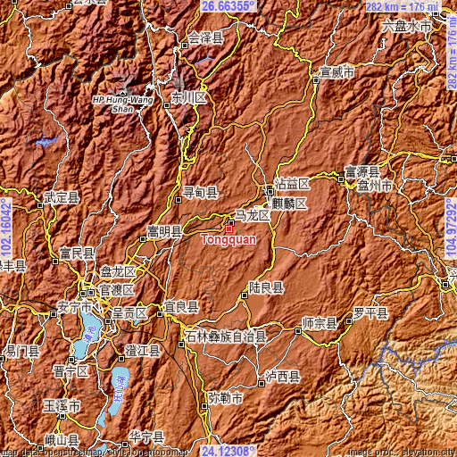
These maps also provides idea of topography and contour of this city, they are displayed at different zoom levels. More info about maps, scale and edge coordinates you can find below images.
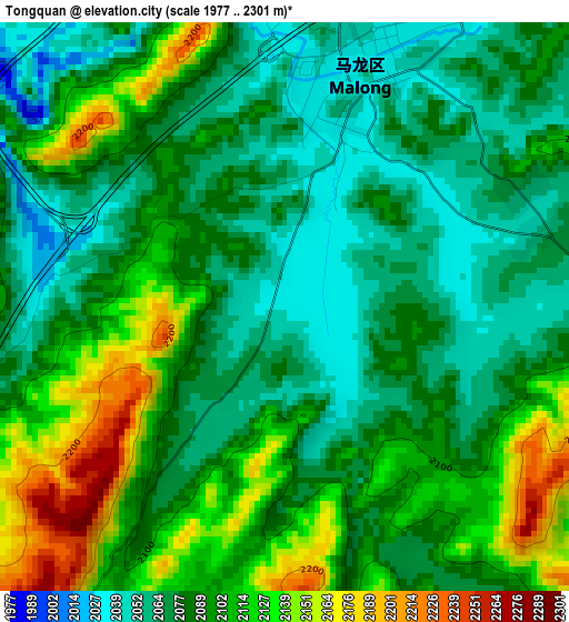
| \ | Map #1 | Topo.Map |
| Scale [m] | 1977..2301 m | × |
| Scale [ft] | 6486..7549 ft | × |
| Average | 2091.7 m = 6863 ft | × |
| Width | 8.83 km = 5.5 mi | 282.5 km = 175.5 mi |
| Height | 8.83 km = 5.5 mi | 282.5 km = 175.5 mi |
| ↑Max Latitude | 25.439691° | 26.66355° |
| Latitude at center | 25.4° | 25.4° |
| ↓Min Latitude | 25.360296° | 24.12308° |
| ← Min Longitude | 103.522725° | 102.16042° |
| Longitude center | 103.56667° | 103.56667° |
| →Max Longitude | 103.610615° | 104.97292° |
Nearby cities:
Cities around Tongquan sort by population:
• Kunming elevation 1895 m
94.3 km,  244°
244°
• Qujing 1887 m
23.6 km,  66°
66°
• Shilin 1786 m
68.8 km,  200°
200°
• Luoxiong 1520 m
92.8 km,  128°
128°
• Danfeng 1837 m
77.4 km,  144°
144°
• Lufu 1681 m
77.3 km, 203°
• Zhong’an 1882 m
73.2 km, 66°
• Kuangyuan 1538 m
68.5 km,  217°
217°
• Songyang 1909 m
54.6 km,  261°
261°
• Zhongshu 1838 m
42.6 km,  166°
166°
• Rende 1865 m
34.1 km,  301°
301°
• Xiping 1865 m
31.8 km,  46°
46°
Multilingual:
 En español:
Tongquan elevación 2034 m.
 En France:
Tongquan élévation 2034 m.
 Auf Deutsch:
Tongquan höhe über dem Meeresspiegel ist 2034 m.

Sources and notes:
- [note 1] Map square and city borders are not equal. Map elevation data is calculated only from area inside that square.
- [src 1] Elevation data from geonames database provided with same terms of usage.
- [src 2] The elevation map of Tongquan is generated using elevation data from NASA's 3 arcsec (90m) resolution SRTM data.
- [src 3] Base (background) map © OpenStreetMap contributors tiles are generated by Geofabrik and OpenTopoMap.
Copyright & License:
This Tongquan Elevation Map is licensed under CC BY-SA. You may reuse any part from this page, if you give a proper credit by linking to this URL:
 More info on terms of use page.