Pisha elevation
Pisha (Sichuan), China elevation is 1204 meters and Pisha elevation in feet is 3950 ft above sea level [src 1]. Pisha is a seat of a third-order administrative division (feature code) with elevation that is 646 meters (2119 ft) bigger than average city elevation in China.
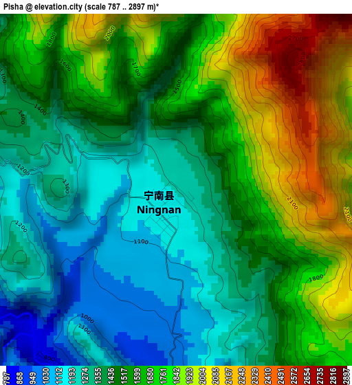
Below is the Elevation map of Pisha, which displays elevation range with different colors. Scale of the first map is from 787 to 2897 m (2582 to 9505 ft) with average elevation of 1546.6 meters (=5074 ft) [note 1]
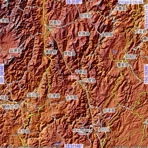
These maps also provides idea of topography and contour of this city, they are displayed at different zoom levels. More info about maps, scale and edge coordinates you can find below images.
| \ | Map #1 | Topo.Map |
| Scale [m] | 787..2897 m | × |
| Scale [ft] | 2582..9505 ft | × |
| Average | 1546.6 m = 5074 ft | × |
| Width | 8.7 km = 5.4 mi | 278.4 km = 173 mi |
| Height | 8.7 km = 5.4 mi | 278.5 km = 173.1 mi |
| ↑Max Latitude | 27.109694° | 28.3157° |
| Latitude at center | 27.07057° | 27.07057° |
| ↓Min Latitude | 27.031432° | 25.81146° |
| ← Min Longitude | 102.713765° | 101.35146° |
| Longitude center | 102.75771° | 102.75771° |
| →Max Longitude | 102.801655° | 104.16396° |
Nearby cities:
Cities around Pisha sort by population:
• Zhaotong elevation 1974 m
98.7 km,  73°
73°
• Tongzilin 1012 m
98.9 km,  245°
245°
• Jinzhong 2874 m
94.5 km,  144°
144°
• Tiandiba 1347 m
85.3 km,  34°
34°
• Wenping 2018 m
77.4 km,  79°
79°
• Temuli 2397 m
71 km,  3°
3°
• Dezhou 1389 m
68.3 km,  303°
303°
• Huili Chengguanzhen 1798 m
68.2 km,  228°
228°
• Panlian 1099 m
67.5 km, 252°
• Huidong 1676 m
51.4 km,  200°
200°
• Puji 1404 m
40.5 km,  328°
328°
• Xinhua 767 m
26.7 km, 139°
Multilingual:
 En español:
Pisha elevación 1204 m.
 En France:
Pisha élévation 1204 m.


Sources and notes:
- [note 1] Map square and city borders are not equal. Map elevation data is calculated only from area inside that square.
- [src 1] Elevation data from geonames database provided with same terms of usage.
- [src 2] The elevation map of Pisha is generated using elevation data from NASA's 3 arcsec (90m) resolution SRTM data.
- [src 3] Base (background) map © OpenStreetMap contributors tiles are generated by Geofabrik and OpenTopoMap.
Copyright & License:
This Pisha Elevation Map is licensed under CC BY-SA. You may reuse any part from this page, if you give a proper credit by linking to this URL:
 More info on terms of use page.