Buchs elevation
Buchs (Saint Gallen, Wahlkreis Werdenberg), Switzerland elevation is 451 meters and Buchs elevation in feet is 1480 ft above sea level [src 1]. Buchs is a populated place (feature code) with elevation that is 97 meters (318 ft) smaller than average city elevation in Switzerland.
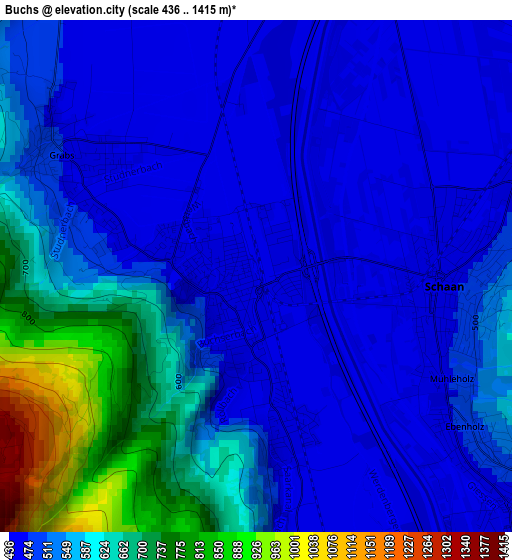
Below is the Elevation map of Buchs, which displays elevation range with different colors. Scale of the first map is from 436 to 1415 m (1430 to 4642 ft) with average elevation of 544.1 meters (=1785 ft) [note 1]
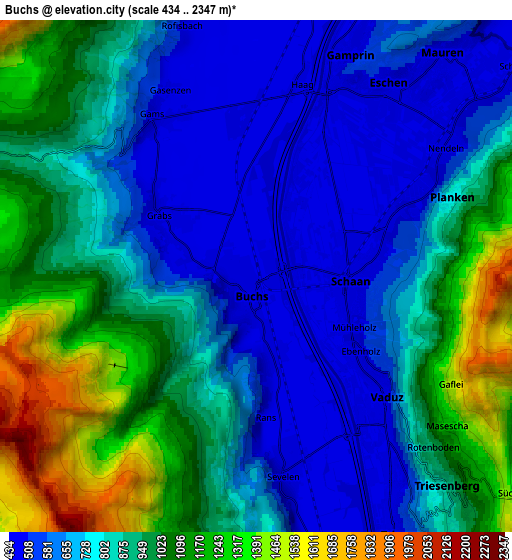
These maps also provides idea of topography and contour of this city, they are displayed at different zoom levels. More info about maps, scale and edge coordinates you can find below images.
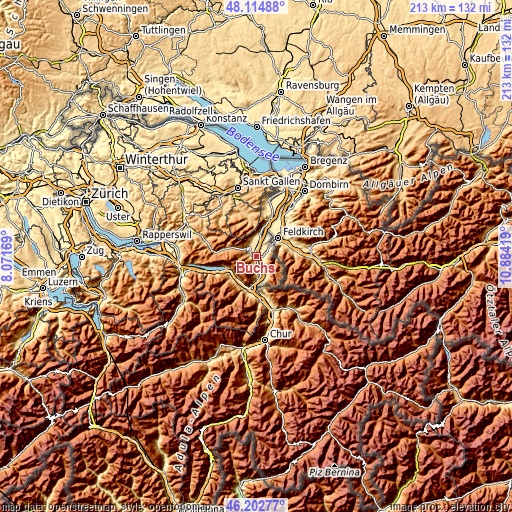
| \ | Map #1 | Map #2 | Topo.Map |
| Scale [m] | 436..1415 m | 434..2347 m | × |
| Scale [ft] | 1430..4642 ft | 1424..7700 ft | × |
| Average | 544.1 m = 1785 ft | 847.6 m = 2781 ft | × |
| Width | 6.64 km = 4.1 mi | 13.29 km = 8.3 mi | 212.6 km = 132.1 mi |
| Height | 6.64 km = 4.1 mi | 13.29 km = 8.3 mi | 212.6 km = 132.1 mi |
| ↑Max Latitude | 47.197298° | 47.22715° | 48.11488° |
| Latitude at center | 47.16743° | 47.16743° | 47.16743° |
| ↓Min Latitude | 47.137545° | 47.107643° | 46.20277° |
| ← Min Longitude | 9.433995° | 9.390049° | 8.07169° |
| Longitude center | 9.47794° | 9.47794° | 9.47794° |
| →Max Longitude | 9.521885° | 9.565831° | 10.88419° |
Nearby cities:
Cities around Buchs sort by population:
• Oberriet elevation 419 m
18.4 km,  21°
21°
• Grabs 474 m
3.1 km,  303°
303°
• Bad Ragaz 512 m
18 km,  174°
174°
• Sargans 487 m
13.5 km,  191°
191°
• Walenstadt 426 m
13.4 km,  249°
249°
• Flums 456 m
13.3 km,  230°
230°
• Sennwald 454 m
10.5 km,  10°
10°
• Sevelen 463 m
5.1 km, 173°
• Gams 483 m
4.9 km,  326°
326°
• Rüthi 433 m
14.9 km, 17°
• Wildhaus 1090 m
10.3 km,  294°
294°
• Haag (Rheintal) 441 m
4.8 km, 10°
Multilingual:
 En español:
Buchs elevación 451 m.
 En France:
Buchs élévation 451 m.
 Auf Deutsch:
Buchs SG höhe über dem Meeresspiegel ist 451 m.

Sources and notes:
- [note 1] Map square and city borders are not equal. Map elevation data is calculated only from area inside that square.
- [src 1] Elevation data from geonames database provided with same terms of usage.
- [src 2] The elevation map of Buchs is generated using elevation data from NASA's 3 arcsec (90m) resolution SRTM data.
- [src 3] Base (background) map © OpenStreetMap contributors tiles are generated by Geofabrik and OpenTopoMap.
Copyright & License:
This Buchs Elevation Map is licensed under CC BY-SA. You may reuse any part from this page, if you give a proper credit by linking to this URL:
 More info on terms of use page.