Bad Ragaz elevation
Bad Ragaz (Saint Gallen, Wahlkreis Sarganserland), Switzerland elevation is 512 meters and Bad Ragaz elevation in feet is 1680 ft above sea level [src 1]. Bad Ragaz is a populated place (feature code) with elevation that is 36 meters (118 ft) smaller than average city elevation in Switzerland.
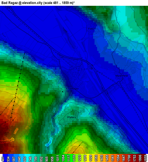
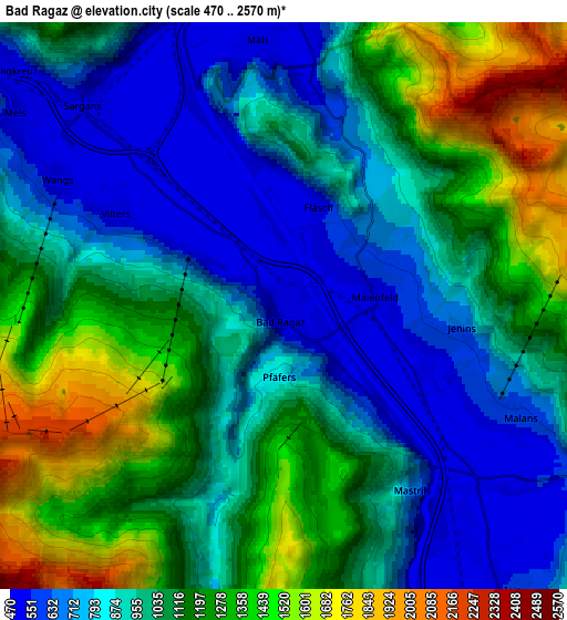
Below is the Elevation map of Bad Ragaz, which displays elevation range with different colors. Scale of the first map is from 481 to 1859 m (1578 to 6099 ft) with average elevation of 739.3 meters (=2426 ft) [note 1]
These maps also provides idea of topography and contour of this city, they are displayed at different zoom levels. More info about maps, scale and edge coordinates you can find below images.
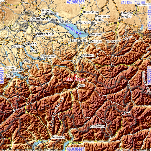
| \ | Map #1 | Map #2 | Topo.Map |
| Scale [m] | 481..1859 m | 470..2570 m | × |
| Scale [ft] | 1578..6099 ft | 1542..8432 ft | × |
| Average | 739.3 m = 2426 ft | 1024.2 m = 3360 ft | × |
| Width | 6.66 km = 4.1 mi | 13.33 km = 8.3 mi | 213.3 km = 132.5 mi |
| Height | 6.66 km = 4.1 mi | 13.33 km = 8.3 mi | 213.2 km = 132.5 mi |
| ↑Max Latitude | 47.035969° | 47.065911° | 47.95636° |
| Latitude at center | 47.00601° | 47.00601° | 47.00601° |
| ↓Min Latitude | 46.976034° | 46.946042° | 46.03844° |
| ← Min Longitude | 9.458715° | 9.414769° | 8.09641° |
| Longitude center | 9.50266° | 9.50266° | 9.50266° |
| →Max Longitude | 9.546605° | 9.590551° | 10.90891° |
Nearby cities:
Cities around Bad Ragaz sort by population:
• Igis elevation 567 m
8.6 km,  141°
141°
• Sargans 487 m
6.7 km,  315°
315°
• Flums 456 m
15.3 km,  307°
307°
• Sevelen 463 m
13 km,  354°
354°
• Zizers 563 m
9.1 km,  148°
148°
• Trimmis 596 m
12.5 km,  159°
159°
• Maienfeld 506 m
2.2 km,  93°
93°
• Schiers 665 m
14.6 km,  106°
106°
• Untervaz 573 m
9.1 km, 164°
• Malans 556 m
6.2 km,  116°
116°
• Grüsch 631 m
11.3 km, 105°
• Landquart 532 m
7.9 km, 142°
Multilingual:
 En español:
Bad Ragaz elevación 512 m.
 En France:
Bad Ragaz élévation 512 m.
 Auf Deutsch:
Bad Ragaz höhe über dem Meeresspiegel ist 512 m.

Sources and notes:
- [note 1] Map square and city borders are not equal. Map elevation data is calculated only from area inside that square.
- [src 1] Elevation data from geonames database provided with same terms of usage.
- [src 2] The elevation map of Bad Ragaz is generated using elevation data from NASA's 3 arcsec (90m) resolution SRTM data.
- [src 3] Base (background) map © OpenStreetMap contributors tiles are generated by Geofabrik and OpenTopoMap.
Copyright & License:
This Bad Ragaz Elevation Map is licensed under CC BY-SA. You may reuse any part from this page, if you give a proper credit by linking to this URL:
 More info on terms of use page.