Grüsch elevation
Grüsch (Grisons, Region Prättigau / Davos), Switzerland elevation is 631 meters and Grüsch elevation in feet is 2070 ft above sea level [src 1]. Grüsch is a populated place (feature code) with elevation that is 83 meters (272 ft) bigger than average city elevation in Switzerland.
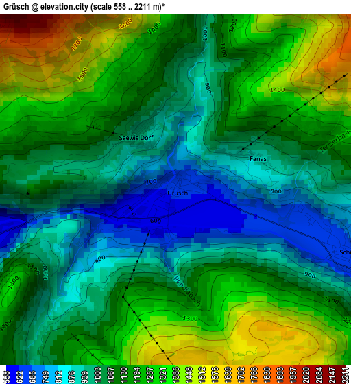
Below is the Elevation map of Grüsch, which displays elevation range with different colors. Scale of the first map is from 558 to 2211 m (1831 to 7254 ft) with average elevation of 1114.8 meters (=3657 ft) [note 1]
These maps also provides idea of topography and contour of this city, they are displayed at different zoom levels. More info about maps, scale and edge coordinates you can find below images.
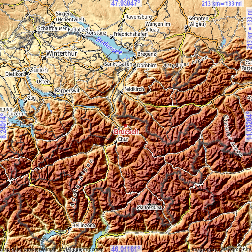
| \ | Map #1 | Topo.Map |
| Scale [m] | 558..2211 m | × |
| Scale [ft] | 1831..7254 ft | × |
| Average | 1114.8 m = 3657 ft | × |
| Width | 6.67 km = 4.1 mi | 213.4 km = 132.6 mi |
| Height | 6.67 km = 4.1 mi | 213.3 km = 132.5 mi |
| ↑Max Latitude | 47.009624° | 47.93047° |
| Latitude at center | 46.97965° | 46.97965° |
| ↓Min Latitude | 46.94966° | 46.01161° |
| ← Min Longitude | 9.602445° | 8.24014° |
| Longitude center | 9.64639° | 9.64639° |
| →Max Longitude | 9.690335° | 11.05264° |
Nearby cities:
Cities around Grüsch sort by population:
• Chur elevation 601 m
16.8 km,  210°
210°
• Igis 567 m
6.8 km,  235°
235°
• Bad Ragaz 512 m
11.3 km,  285°
285°
• Zizers 563 m
7.9 km,  231°
231°
• Trimmis 596 m
10.9 km,  216°
216°
• Maienfeld 506 m
9.2 km, 287°
• Schiers 665 m
3.3 km,  109°
109°
• Untervaz 573 m
10.3 km, 235°
• Malans 556 m
5.4 km,  271°
271°
• Luzein 950 m
11 km,  127°
127°
• Jenaz 779 m
7.6 km,  138°
138°
• Landquart 532 m
6.9 km, 241°
Multilingual:
 En español:
Grüsch elevación 631 m.
 En France:
Grüsch élévation 631 m.


Sources and notes:
- [note 1] Map square and city borders are not equal. Map elevation data is calculated only from area inside that square.
- [src 1] Elevation data from geonames database provided with same terms of usage.
- [src 2] The elevation map of Grüsch is generated using elevation data from NASA's 3 arcsec (90m) resolution SRTM data.
- [src 3] Base (background) map © OpenStreetMap contributors tiles are generated by Geofabrik and OpenTopoMap.
Copyright & License:
This Grüsch Elevation Map is licensed under CC BY-SA. You may reuse any part from this page, if you give a proper credit by linking to this URL:
 More info on terms of use page.