Chur elevation
Chur (Grisons, Region Plessur), Switzerland elevation is 601 meters and Chur elevation in feet is 1972 ft above sea level [src 1]. Chur is a seat of a first-order administrative division (feature code) with elevation that is 53 meters (174 ft) bigger than average city elevation in Switzerland.
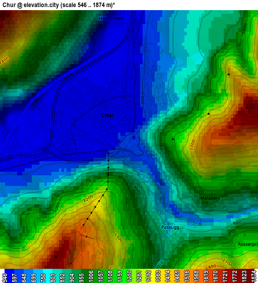
Below is the Elevation map of Chur, which displays elevation range with different colors. Scale of the first map is from 546 to 1874 m (1791 to 6148 ft) with average elevation of 947.4 meters (=3108 ft) [note 1]
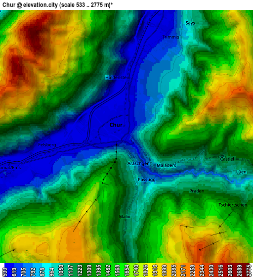
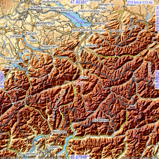
These maps also provides idea of topography and contour of this city, they are displayed at different zoom levels. More info about maps, scale and edge coordinates you can find below images.
| \ | Map #1 | Map #2 | Topo.Map |
| Scale [m] | 546..1874 m | 533..2775 m | × |
| Scale [ft] | 1791..6148 ft | 1749..9104 ft | × |
| Average | 947.4 m = 3108 ft | 1349.2 m = 4427 ft | × |
| Width | 6.68 km = 4.2 mi | 13.37 km = 8.3 mi | 213.9 km = 132.9 mi |
| Height | 6.68 km = 4.2 mi | 13.37 km = 8.3 mi | 213.9 km = 132.9 mi |
| ↑Max Latitude | 46.879906° | 46.909936° | 47.80301° |
| Latitude at center | 46.84986° | 46.84986° | 46.84986° |
| ↓Min Latitude | 46.819797° | 46.789717° | 45.87949° |
| ← Min Longitude | 9.488925° | 9.444979° | 8.12662° |
| Longitude center | 9.53287° | 9.53287° | 9.53287° |
| →Max Longitude | 9.576815° | 9.620761° | 10.93912° |
Nearby cities:
Cities around Chur sort by population:
• Igis elevation 567 m
11 km,  15°
15°
• Domat 585 m
6.5 km,  255°
255°
• Zizers 563 m
9.9 km,  14°
14°
• Trimmis 596 m
6.1 km, 20°
• Bonaduz 658 m
11.1 km,  247°
247°
• Arosa 1801 m
13.5 km,  126°
126°
• Untervaz 573 m
8.6 km,  0°
0°
• Felsberg 570 m
4.4 km, 263°
• Rhäzüns 659 m
11.7 km,  241°
241°
• Churwalden 1252 m
7.7 km,  173°
173°
• Tamins 667 m
9.9 km, 256°
• Landquart 532 m
11.4 km, 12°
Multilingual:
 En español:
Coira elevación 601 m.
 En France:
Coire élévation 601 m.


Sources and notes:
- [note 1] Map square and city borders are not equal. Map elevation data is calculated only from area inside that square.
- [src 1] Elevation data from geonames database provided with same terms of usage.
- [src 2] The elevation map of Chur is generated using elevation data from NASA's 3 arcsec (90m) resolution SRTM data.
- [src 3] Base (background) map © OpenStreetMap contributors tiles are generated by Geofabrik and OpenTopoMap.
Copyright & License:
This Chur Elevation Map is licensed under CC BY-SA. You may reuse any part from this page, if you give a proper credit by linking to this URL:
 More info on terms of use page.