Rhäzüns elevation
Rhäzüns (Grisons, Region Imboden), Switzerland elevation is 659 meters and Rhäzüns elevation in feet is 2162 ft above sea level [src 1]. Rhäzüns is a populated place (feature code) with elevation that is 111 meters (364 ft) bigger than average city elevation in Switzerland.
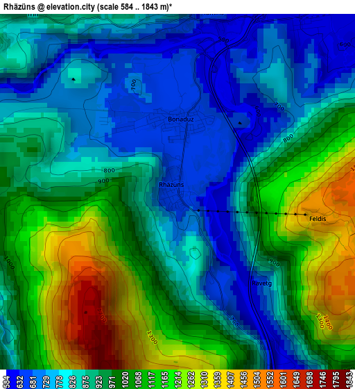
Below is the Elevation map of Rhäzüns, which displays elevation range with different colors. Scale of the first map is from 584 to 1843 m (1916 to 6047 ft) with average elevation of 937.9 meters (=3077 ft) [note 1]
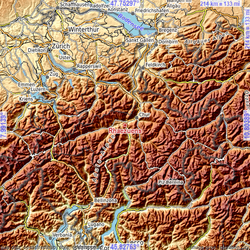
These maps also provides idea of topography and contour of this city, they are displayed at different zoom levels. More info about maps, scale and edge coordinates you can find below images.
| \ | Map #1 | Topo.Map |
| Scale [m] | 584..1843 m | × |
| Scale [ft] | 1916..6047 ft | × |
| Average | 937.9 m = 3077 ft | × |
| Width | 6.69 km = 4.2 mi | 214.1 km = 133 mi |
| Height | 6.69 km = 4.2 mi | 214.1 km = 133 mi |
| ↑Max Latitude | 46.828985° | 47.75297° |
| Latitude at center | 46.79891° | 46.79891° |
| ↓Min Latitude | 46.768818° | 45.82763° |
| ← Min Longitude | 9.353695° | 7.99139° |
| Longitude center | 9.39764° | 9.39764° |
| →Max Longitude | 9.441585° | 10.80389° |
Nearby cities:
Cities around Rhäzüns sort by population:
• Chur elevation 601 m
11.7 km,  61°
61°
• Domat 585 m
5.7 km,  45°
45°
• Bonaduz 658 m
1.3 km,  1°
1°
• Lenzerheide 1471 m
15 km,  124°
124°
• Thusis 721 m
11.7 km,  164°
164°
• Flims 1085 m
9.6 km,  296°
296°
• Felsberg 570 m
7.9 km, 48°
• Cazis 659 m
9.2 km, 163°
• Laax 1011 m
10.7 km,  273°
273°
• Churwalden 1252 m
11.3 km,  99°
99°
• Tamins 667 m
3.5 km,  11°
11°
• Scharans 765 m
10.1 km,  152°
152°
Multilingual:
 En español:
Rhäzüns elevación 659 m.
 En France:
Rhäzüns élévation 659 m.


Sources and notes:
- [note 1] Map square and city borders are not equal. Map elevation data is calculated only from area inside that square.
- [src 1] Elevation data from geonames database provided with same terms of usage.
- [src 2] The elevation map of Rhäzüns is generated using elevation data from NASA's 3 arcsec (90m) resolution SRTM data.
- [src 3] Base (background) map © OpenStreetMap contributors tiles are generated by Geofabrik and OpenTopoMap.
Copyright & License:
This Rhäzüns Elevation Map is licensed under CC BY-SA. You may reuse any part from this page, if you give a proper credit by linking to this URL:
 More info on terms of use page.