Rüthi elevation
Rüthi (Saint Gallen, Wahlkreis Rheintal), Switzerland elevation is 433 meters and Rüthi elevation in feet is 1421 ft above sea level [src 1]. Rüthi is a populated place (feature code) with elevation that is 115 meters (377 ft) smaller than average city elevation in Switzerland.
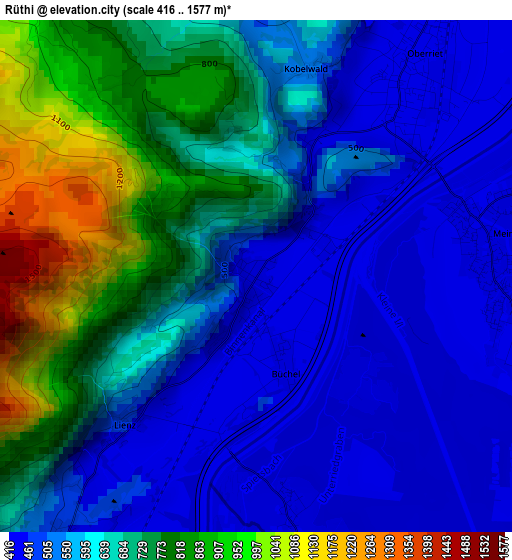
Below is the Elevation map of Rüthi, which displays elevation range with different colors. Scale of the first map is from 416 to 1577 m (1365 to 5174 ft) with average elevation of 625.3 meters (=2052 ft) [note 1]
These maps also provides idea of topography and contour of this city, they are displayed at different zoom levels. More info about maps, scale and edge coordinates you can find below images.
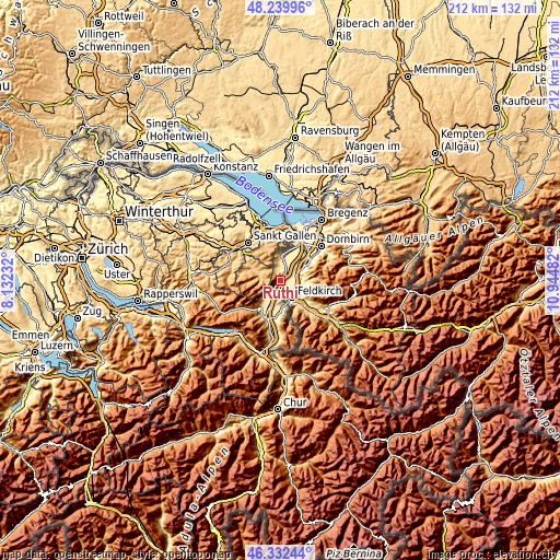
| \ | Map #1 | Topo.Map |
| Scale [m] | 416..1577 m | × |
| Scale [ft] | 1365..5174 ft | × |
| Average | 625.3 m = 2052 ft | × |
| Width | 6.63 km = 4.1 mi | 212.1 km = 131.8 mi |
| Height | 6.63 km = 4.1 mi | 212.1 km = 131.8 mi |
| ↑Max Latitude | 47.324596° | 48.23996° |
| Latitude at center | 47.2948° | 47.2948° |
| ↓Min Latitude | 47.264987° | 46.33244° |
| ← Min Longitude | 9.494625° | 8.13232° |
| Longitude center | 9.53857° | 9.53857° |
| →Max Longitude | 9.582515° | 10.94482° |
Nearby cities:
Cities around Rüthi sort by population:
• Altstätten elevation 447 m
9.2 km,  4°
4°
• Oberriet 419 m
3.7 km,  37°
37°
• Appenzell 783 m
10.5 km,  292°
292°
• Diepoldsau 411 m
13.4 km, 41°
• Sennwald 454 m
4.7 km,  215°
215°
• Rebstein 417 m
12 km,  16°
16°
• Balgach 408 m
13.4 km, 22°
• Gams 483 m
12.4 km, 215°
• Gais 924 m
9.8 km,  319°
319°
• Bühler 831 m
12.2 km, 315°
• Eichberg 469 m
5.5 km,  354°
354°
• Haag (Rheintal) 441 m
10.1 km,  201°
201°
Multilingual:
 En español:
Rüthi elevación 433 m.
 En France:
Rüthi élévation 433 m.


Sources and notes:
- [note 1] Map square and city borders are not equal. Map elevation data is calculated only from area inside that square.
- [src 1] Elevation data from geonames database provided with same terms of usage.
- [src 2] The elevation map of Rüthi is generated using elevation data from NASA's 3 arcsec (90m) resolution SRTM data.
- [src 3] Base (background) map © OpenStreetMap contributors tiles are generated by Geofabrik and OpenTopoMap.
Copyright & License:
This Rüthi Elevation Map is licensed under CC BY-SA. You may reuse any part from this page, if you give a proper credit by linking to this URL:
 More info on terms of use page.