Altstätten elevation
Altstätten (Saint Gallen, Wahlkreis Rheintal), Switzerland elevation is 447 meters and Altstätten elevation in feet is 1467 ft above sea level [src 1]. Altstätten is a populated place (feature code) with elevation that is 101 meters (331 ft) smaller than average city elevation in Switzerland.
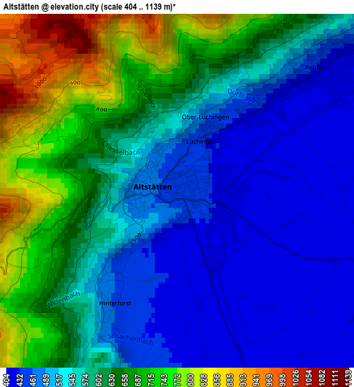
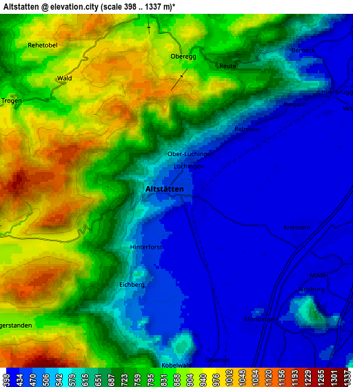
Below is the Elevation map of Altstätten, which displays elevation range with different colors. Scale of the first map is from 404 to 1139 m (1325 to 3737 ft) with average elevation of 581 meters (=1906 ft) [note 1]
These maps also provides idea of topography and contour of this city, they are displayed at different zoom levels. More info about maps, scale and edge coordinates you can find below images.
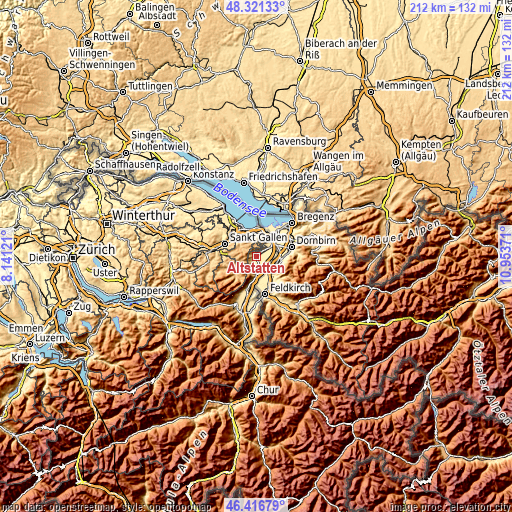
| \ | Map #1 | Map #2 | Topo.Map |
| Scale [m] | 404..1139 m | 398..1337 m | × |
| Scale [ft] | 1325..3737 ft | 1306..4386 ft | × |
| Average | 581 m = 1906 ft | 679.7 m = 2230 ft | × |
| Width | 6.62 km = 4.1 mi | 13.24 km = 8.2 mi | 211.8 km = 131.6 mi |
| Height | 6.62 km = 4.1 mi | 13.24 km = 8.2 mi | 211.8 km = 131.6 mi |
| ↑Max Latitude | 47.40741° | 47.437143° | 48.32133° |
| Latitude at center | 47.37766° | 47.37766° | 47.37766° |
| ↓Min Latitude | 47.347893° | 47.31811° | 46.41679° |
| ← Min Longitude | 9.503515° | 9.459569° | 8.14121° |
| Longitude center | 9.54746° | 9.54746° | 9.54746° |
| →Max Longitude | 9.591405° | 9.635351° | 10.95371° |
Nearby cities:
Cities around Altstätten sort by population:
• Oberriet elevation 419 m
6.5 km,  166°
166°
• Au 403 m
8.8 km,  47°
47°
• Diepoldsau 411 m
8.2 km,  83°
83°
• Rebstein 417 m
3.6 km, 51°
• Balgach 408 m
5.5 km,  55°
55°
• Heiden 786 m
7.3 km,  351°
351°
• Speicher 927 m
8.7 km,  295°
295°
• Gais 924 m
7.3 km,  255°
255°
• Oberegg 875 m
5.3 km,  3°
3°
• Rehetobel 946 m
7.2 km,  317°
317°
• Trogen 904 m
7.1 km, 298°
• Eichberg 469 m
4 km,  197°
197°
Multilingual:
 En español:
Altstätten elevación 447 m.
 En France:
Altstätten élévation 447 m.
 Auf Deutsch:
Altstätten SG höhe über dem Meeresspiegel ist 447 m.

Sources and notes:
- [note 1] Map square and city borders are not equal. Map elevation data is calculated only from area inside that square.
- [src 1] Elevation data from geonames database provided with same terms of usage.
- [src 2] The elevation map of Altstätten is generated using elevation data from NASA's 3 arcsec (90m) resolution SRTM data.
- [src 3] Base (background) map © OpenStreetMap contributors tiles are generated by Geofabrik and OpenTopoMap.
Copyright & License:
This Altstätten Elevation Map is licensed under CC BY-SA. You may reuse any part from this page, if you give a proper credit by linking to this URL:
 More info on terms of use page.