Bondo elevation
Bondo (Bas-Uele), Democratic Republic of the Congo elevation is 494 meters and Bondo elevation in feet is 1621 ft above sea level [src 1]. Bondo is a populated place (feature code) with elevation that is 162 meters (531 ft) smaller than average city elevation in Democratic Republic of the Congo.
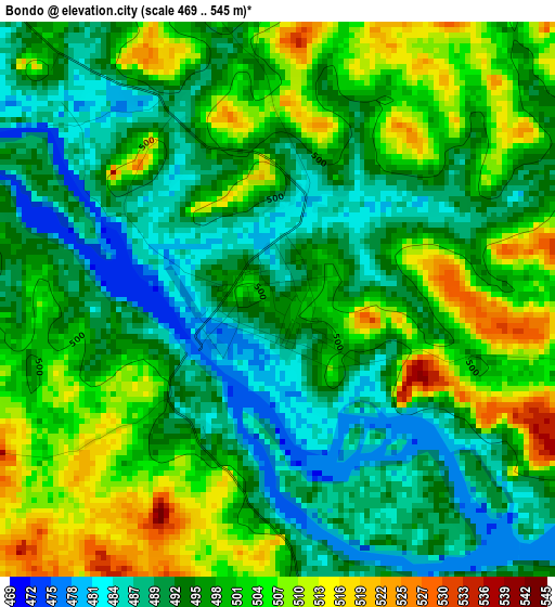
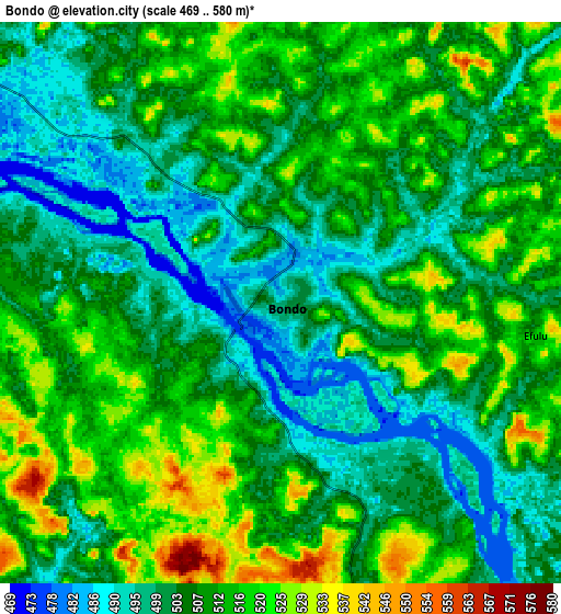
Below is the Elevation map of Bondo, which displays elevation range with different colors. Scale of the first map is from 469 to 545 m (1539 to 1788 ft) with average elevation of 497.6 meters (=1633 ft) [note 1]
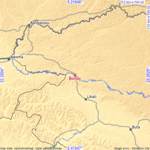
These maps also provides idea of topography and contour of this city, they are displayed at different zoom levels. More info about maps, scale and edge coordinates you can find below images.
| \ | Map #1 | Map #2 | Topo.Map |
| Scale [m] | 469..545 m | 469..580 m | × |
| Scale [ft] | 1539..1788 ft | 1539..1903 ft | × |
| Average | 497.6 m = 1633 ft | 507.6 m = 1665 ft | × |
| Width | 9.75 km = 6.1 mi | 19.5 km = 12.1 mi | 312 km = 193.9 mi |
| Height | 9.75 km = 6.1 mi | 19.5 km = 12.1 mi | 312 km = 193.9 mi |
| ↑Max Latitude | 3.858457° | 3.902301° | 5.21646° |
| Latitude at center | 3.81461° | 3.81461° | 3.81461° |
| ↓Min Latitude | 3.770761° | 3.72691° | 2.41047° |
| ← Min Longitude | 23.642705° | 23.598759° | 22.2804° |
| Longitude center | 23.68665° | 23.68665° | 23.68665° |
| →Max Longitude | 23.730595° | 23.774541° | 25.0929° |
Nearby cities:
Cities around Bondo sort by population:
• Kisangani elevation 400 m
403.1 km,  155°
155°
• Gemena 420 m
438.8 km,  261°
261°
• Bumba 362 m
225.9 km,  216°
216°
• Lisala 418 m
303.7 km,  232°
232°
• Gbadolite 416 m
302.1 km,  279°
279°
• Buta 402 m
162.8 km,  134°
134°
• Basoko 375 m
286.5 km,  181°
181°
• Yangambi 459 m
349 km,  166°
166°
• Aketi 380 m
120.1 km, 174°
• Businga 362 m
315.3 km, 260°
• Bosobolo 442 m
423.9 km, 275°
• Bongandanga 389 m
387.5 km, 228°
Multilingual:
 En español:
Bondo elevación 494 m.
 En France:
Bondo élévation 494 m.


Sources and notes:
- [note 1] Map square and city borders are not equal. Map elevation data is calculated only from area inside that square.
- [src 1] Elevation data from geonames database provided with same terms of usage.
- [src 2] The elevation map of Bondo is generated using elevation data from NASA's 3 arcsec (90m) resolution SRTM data.
- [src 3] Base (background) map © OpenStreetMap contributors tiles are generated by Geofabrik and OpenTopoMap.
Copyright & License:
This Bondo Elevation Map is licensed under CC BY-SA. You may reuse any part from this page, if you give a proper credit by linking to this URL:
 More info on terms of use page.