Bongandanga elevation
Bongandanga (Sud-Ubangi), Democratic Republic of the Congo elevation is 389 meters and Bongandanga elevation in feet is 1276 ft above sea level [src 1]. Bongandanga is a populated place (feature code) with elevation that is 267 meters (876 ft) smaller than average city elevation in Democratic Republic of the Congo.
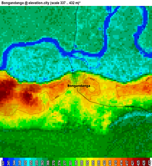
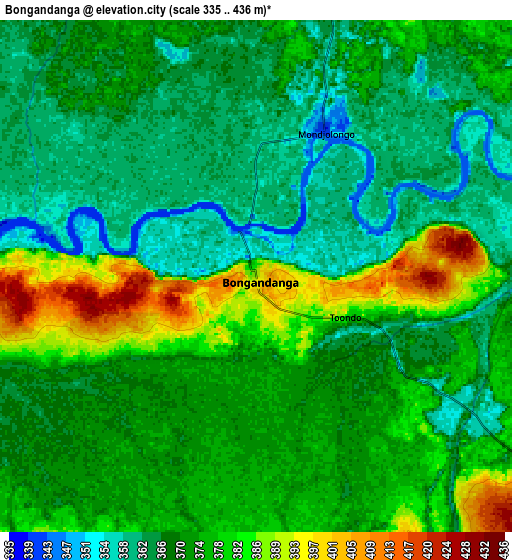
Below is the Elevation map of Bongandanga, which displays elevation range with different colors. Scale of the first map is from 337 to 432 m (1106 to 1417 ft) with average elevation of 371.7 meters (=1219 ft) [note 1]
These maps also provides idea of topography and contour of this city, they are displayed at different zoom levels. More info about maps, scale and edge coordinates you can find below images.
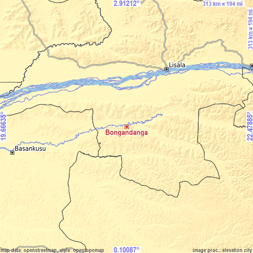
| \ | Map #1 | Map #2 | Topo.Map |
| Scale [m] | 337..432 m | 335..436 m | × |
| Scale [ft] | 1106..1417 ft | 1099..1430 ft | × |
| Average | 371.7 m = 1219 ft | 371.6 m = 1219 ft | × |
| Width | 9.77 km = 6.1 mi | 19.54 km = 12.1 mi | 312.6 km = 194.2 mi |
| Height | 9.77 km = 6.1 mi | 19.54 km = 12.1 mi | 312.6 km = 194.2 mi |
| ↑Max Latitude | 1.55088° | 1.594808° | 2.91212° |
| Latitude at center | 1.50695° | 1.50695° | 1.50695° |
| ↓Min Latitude | 1.463019° | 1.419088° | 0.10087° |
| ← Min Longitude | 21.028655° | 20.984709° | 19.66635° |
| Longitude center | 21.0726° | 21.0726° | 21.0726° |
| →Max Longitude | 21.116545° | 21.160491° | 22.47885° |
Nearby cities:
Cities around Bongandanga sort by population:
• Mbandaka elevation 315 m
352.2 km,  242°
242°
• Gemena 420 m
242.3 km,  323°
323°
• Bumba 362 m
172.6 km,  63°
63°
• Lisala 418 m
87 km,  34°
34°
• Gbadolite 416 m
308.3 km,  358°
358°
• Basoko 375 m
284.3 km,  96°
96°
• Yangambi 459 m
383.2 km, 102°
• Aketi 380 m
330.9 km,  65°
65°
• Boende 349 m
200 km,  186°
186°
• Businga 362 m
204.7 km,  354°
354°
• Libenge 358 m
360.9 km,  311°
311°
• Bosobolo 442 m
326.2 km,  336°
336°
Multilingual:
 En español:
Bongandanga elevación 389 m.
 En France:
Bongandanga élévation 389 m.
 Auf Deutsch:
Bongandanga höhe über dem Meeresspiegel ist 389 m.

Sources and notes:
- [note 1] Map square and city borders are not equal. Map elevation data is calculated only from area inside that square.
- [src 1] Elevation data from geonames database provided with same terms of usage.
- [src 2] The elevation map of Bongandanga is generated using elevation data from NASA's 3 arcsec (90m) resolution SRTM data.
- [src 3] Base (background) map © OpenStreetMap contributors tiles are generated by Geofabrik and OpenTopoMap.
Copyright & License:
This Bongandanga Elevation Map is licensed under CC BY-SA. You may reuse any part from this page, if you give a proper credit by linking to this URL:
 More info on terms of use page.