Kisangani elevation
Kisangani (Tshopo), Democratic Republic of the Congo elevation is 400 meters and Kisangani elevation in feet is 1312 ft above sea level [src 1]. Kisangani is a seat of a first-order administrative division (feature code) with elevation that is 256 meters (840 ft) smaller than average city elevation in Democratic Republic of the Congo.
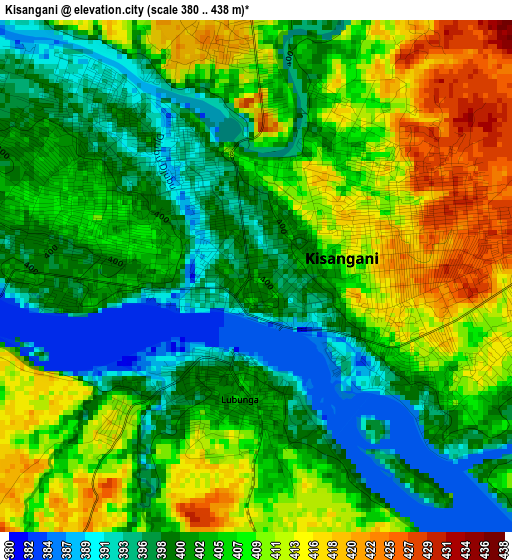
Below is the Elevation map of Kisangani, which displays elevation range with different colors. Scale of the first map is from 380 to 438 m (1247 to 1437 ft) with average elevation of 404.4 meters (=1327 ft) [note 1]
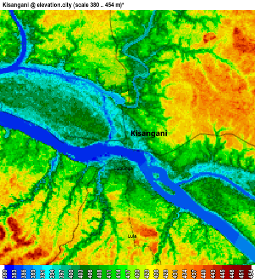
These maps also provides idea of topography and contour of this city, they are displayed at different zoom levels. More info about maps, scale and edge coordinates you can find below images.
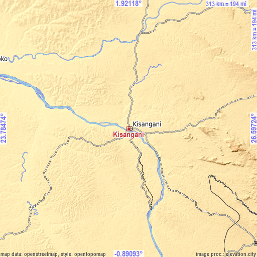
| \ | Map #1 | Map #2 | Topo.Map |
| Scale [m] | 380..438 m | 380..454 m | × |
| Scale [ft] | 1247..1437 ft | 1247..1490 ft | × |
| Average | 404.4 m = 1327 ft | 412.8 m = 1354 ft | × |
| Width | 9.77 km = 6.1 mi | 19.54 km = 12.1 mi | 312.7 km = 194.3 mi |
| Height | 9.77 km = 6.1 mi | 19.54 km = 12.1 mi | 312.7 km = 194.3 mi |
| ↑Max Latitude | 0.559223° | 0.603166° | 1.92118° |
| Latitude at center | 0.51528° | 0.51528° | 0.51528° |
| ↓Min Latitude | 0.471336° | 0.427392° | -0.89093° |
| ← Min Longitude | 25.147045° | 25.103099° | 23.78474° |
| Longitude center | 25.19099° | 25.19099° | 25.19099° |
| →Max Longitude | 25.234935° | 25.278881° | 26.59724° |
Nearby cities:
Cities around Kisangani sort by population:
• Kindu elevation 464 m
393.1 km,  168°
168°
• Isiro 761 m
368.4 km,  47°
47°
• Bumba 362 m
355.2 km,  301°
301°
• Buta 402 m
257.6 km,  348°
348°
• Basoko 375 m
192.7 km,  294°
294°
• Yangambi 459 m
88.1 km, 288°
• Aketi 380 m
292.6 km,  327°
327°
• Bondo 494 m
403.1 km,  335°
335°
• Wamba 796 m
360.7 km,  59°
59°
Multilingual:
 En español:
Kisangani elevación 400 m.
 En France:
Kisangani, Stanleyville élévation 400 m.
 Auf Deutsch:
Kisangani höhe über dem Meeresspiegel ist 400 m.

Sources and notes:
- [note 1] Map square and city borders are not equal. Map elevation data is calculated only from area inside that square.
- [src 1] Elevation data from geonames database provided with same terms of usage.
- [src 2] The elevation map of Kisangani is generated using elevation data from NASA's 3 arcsec (90m) resolution SRTM data.
- [src 3] Base (background) map © OpenStreetMap contributors tiles are generated by Geofabrik and OpenTopoMap.
Copyright & License:
This Kisangani Elevation Map is licensed under CC BY-SA. You may reuse any part from this page, if you give a proper credit by linking to this URL:
 More info on terms of use page.