Viking elevation
Viking (Alberta), Canada elevation is 683 meters and Viking elevation in feet is 2241 ft above sea level [src 1]. Viking is a populated place (feature code) with elevation that is 425 meters (1394 ft) bigger than average city elevation in Canada.
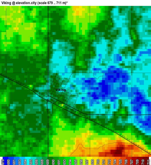
Below is the Elevation map of Viking, which displays elevation range with different colors. Scale of the first map is from 679 to 711 m (2228 to 2333 ft) with average elevation of 689.9 meters (=2263 ft) [note 1]
These maps also provides idea of topography and contour of this city, they are displayed at different zoom levels. More info about maps, scale and edge coordinates you can find below images.
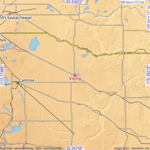
| \ | Map #1 | Topo.Map |
| Scale [m] | 679..711 m | × |
| Scale [ft] | 2228..2333 ft | × |
| Average | 689.9 m = 2263 ft | × |
| Width | 5.87 km = 3.6 mi | 187.8 km = 116.7 mi |
| Height | 5.87 km = 3.6 mi | 187.8 km = 116.7 mi |
| ↑Max Latitude | 53.126517° | 53.93622° |
| Latitude at center | 53.10014° | 53.10014° |
| ↓Min Latitude | 53.073746° | 52.24749° |
| ← Min Longitude | -111.812385° | -113.17469° |
| Longitude center | -111.76844° | -111.76844° |
| →Max Longitude | -111.724495° | -110.36219° |
Nearby cities:
Cities around Viking sort by population:
• Camrose elevation 739 m
71.9 km,  262°
262°
• Wetaskiwin 758 m
108 km, 262°
• St. Paul 632 m
103.3 km,  18°
18°
• Vegreville 635 m
48.3 km,  337°
337°
• Stettler 814 m
108.1 km,  216°
216°
• Wainwright 680 m
68 km,  115°
115°
• Vermilion 617 m
66.8 km,  65°
65°
• Tofield 697 m
66.8 km,  296°
296°
• Lamont 643 m
100.9 km,  317°
317°
• Elk Point 601 m
105.8 km,  32°
32°
• Two Hills 621 m
68.6 km,  0°
0°
• Killam 677 m
35.7 km,  189°
189°
Multilingual:
 En español:
Viking elevación 683 m.
 En France:
Viking élévation 683 m.


Sources and notes:
- [note 1] Map square and city borders are not equal. Map elevation data is calculated only from area inside that square.
- [src 1] Elevation data from geonames database provided with same terms of usage.
- [src 2] The elevation map of Viking is generated using elevation data from NASA's 3 arcsec (90m) resolution SRTM data.
- [src 3] Base (background) map © OpenStreetMap contributors tiles are generated by Geofabrik and OpenTopoMap.
Copyright & License:
This Viking Elevation Map is licensed under CC BY-SA. You may reuse any part from this page, if you give a proper credit by linking to this URL:
 More info on terms of use page.