Stettler elevation
Stettler (Alberta), Canada elevation is 814 meters and Stettler elevation in feet is 2671 ft above sea level [src 1]. Stettler is a populated place (feature code) with elevation that is 556 meters (1824 ft) bigger than average city elevation in Canada.
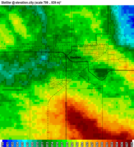
Below is the Elevation map of Stettler, which displays elevation range with different colors. Scale of the first map is from 799 to 839 m (2621 to 2753 ft) with average elevation of 818.5 meters (=2685 ft) [note 1]
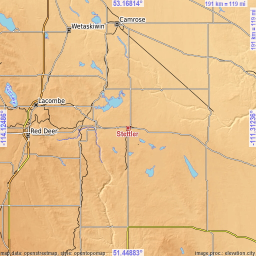
These maps also provides idea of topography and contour of this city, they are displayed at different zoom levels. More info about maps, scale and edge coordinates you can find below images.

| \ | Map #1 | Map #2 | Topo.Map |
| Scale [m] | 799..839 m | 787..843 m | × |
| Scale [ft] | 2621..2753 ft | 2582..2766 ft | × |
| Average | 818.5 m = 2685 ft | 816.1 m = 2677 ft | × |
| Width | 5.97 km = 3.7 mi | 11.95 km = 7.4 mi | 191.2 km = 118.8 mi |
| Height | 5.97 km = 3.7 mi | 11.95 km = 7.4 mi | 191.2 km = 118.8 mi |
| ↑Max Latitude | 52.343685° | 52.370524° | 53.16814° |
| Latitude at center | 52.31683° | 52.31683° | 52.31683° |
| ↓Min Latitude | 52.289958° | 52.26307° | 51.44883° |
| ← Min Longitude | -112.762555° | -112.806501° | -114.12486° |
| Longitude center | -112.71861° | -112.71861° | -112.71861° |
| →Max Longitude | -112.674665° | -112.630719° | -111.31236° |
Nearby cities:
Cities around Stettler sort by population:
• Red Deer elevation 856 m
73.9 km,  265°
265°
• Camrose 739 m
78.2 km,  354°
354°
• Wetaskiwin 758 m
84.5 km,  328°
328°
• Sylvan Lake 961 m
92.8 km, 269°
• Lacombe 853 m
71 km,  283°
283°
• Ponoka 806 m
70.8 km,  304°
304°
• Blackfalds 876 m
72.8 km, 275°
• Hanna 826 m
94.4 km,  143°
143°
• Three Hills 897 m
78.2 km,  208°
208°
• Penhold 895 m
80.9 km,  255°
255°
• Springbrook 899 m
80.5 km, 259°
• Killam 677 m
78.3 km,  48°
48°
Multilingual:
 En español:
Stettler elevación 814 m.
 En France:
Stettler élévation 814 m.
 Auf Deutsch:
Stettler höhe über dem Meeresspiegel ist 814 m.

Sources and notes:
- [note 1] Map square and city borders are not equal. Map elevation data is calculated only from area inside that square.
- [src 1] Elevation data from geonames database provided with same terms of usage.
- [src 2] The elevation map of Stettler is generated using elevation data from NASA's 3 arcsec (90m) resolution SRTM data.
- [src 3] Base (background) map © OpenStreetMap contributors tiles are generated by Geofabrik and OpenTopoMap.
Copyright & License:
This Stettler Elevation Map is licensed under CC BY-SA. You may reuse any part from this page, if you give a proper credit by linking to this URL:
 More info on terms of use page.