Hanna elevation
Hanna (Alberta), Canada elevation is 826 meters and Hanna elevation in feet is 2710 ft above sea level [src 1]. Hanna is a populated place (feature code) with elevation that is 568 meters (1864 ft) bigger than average city elevation in Canada.
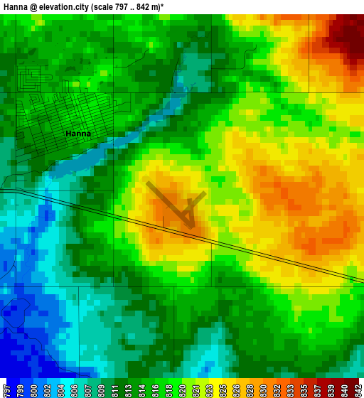
Below is the Elevation map of Hanna, which displays elevation range with different colors. Scale of the first map is from 797 to 842 m (2615 to 2762 ft) with average elevation of 816.4 meters (=2678 ft) [note 1]
These maps also provides idea of topography and contour of this city, they are displayed at different zoom levels. More info about maps, scale and edge coordinates you can find below images.
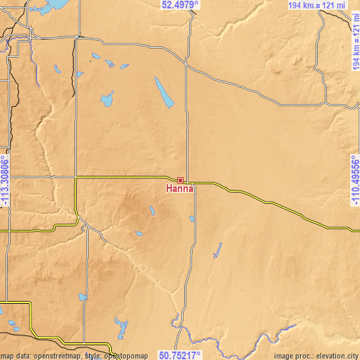
| \ | Map #1 | Topo.Map |
| Scale [m] | 797..842 m | × |
| Scale [ft] | 2615..2762 ft | × |
| Average | 816.4 m = 2678 ft | × |
| Width | 6.07 km = 3.8 mi | 194.1 km = 120.6 mi |
| Height | 6.07 km = 3.8 mi | 194.1 km = 120.6 mi |
| ↑Max Latitude | 51.660698° | 52.4979° |
| Latitude at center | 51.63343° | 51.63343° |
| ↓Min Latitude | 51.606145° | 50.75217° |
| ← Min Longitude | -111.945755° | -113.30806° |
| Longitude center | -111.90181° | -111.90181° |
| →Max Longitude | -111.857865° | -110.49556° |
Nearby cities:
Cities around Hanna sort by population:
• Red Deer elevation 856 m
148 km,  298°
298°
• Strathmore 976 m
121.7 km,  237°
237°
• Brooks 748 m
116.8 km,  179°
179°
• Stettler 814 m
94.4 km,  323°
323°
• Chestermere 1022 m
148.9 km, 243°
• Three Hills 897 m
94.6 km,  274°
274°
• Provost 666 m
137.3 km,  54°
54°
• Penhold 895 m
146 km,  292°
292°
• Springbrook 899 m
148.6 km, 294°
• Bassano 790 m
102.4 km,  202°
202°
• Irricana 931 m
122.8 km,  253°
253°
• Killam 677 m
127.9 km,  1°
1°
Multilingual:
 En español:
Hanna elevación 826 m.
 En France:
Hanna élévation 826 m.


Sources and notes:
- [note 1] Map square and city borders are not equal. Map elevation data is calculated only from area inside that square.
- [src 1] Elevation data from geonames database provided with same terms of usage.
- [src 2] The elevation map of Hanna is generated using elevation data from NASA's 3 arcsec (90m) resolution SRTM data.
- [src 3] Base (background) map © OpenStreetMap contributors tiles are generated by Geofabrik and OpenTopoMap.
Copyright & License:
This Hanna Elevation Map is licensed under CC BY-SA. You may reuse any part from this page, if you give a proper credit by linking to this URL:
 More info on terms of use page.