Provost elevation
Provost (Alberta), Canada elevation is 666 meters and Provost elevation in feet is 2185 ft above sea level [src 1]. Provost is a populated place (feature code) with elevation that is 408 meters (1339 ft) bigger than average city elevation in Canada.
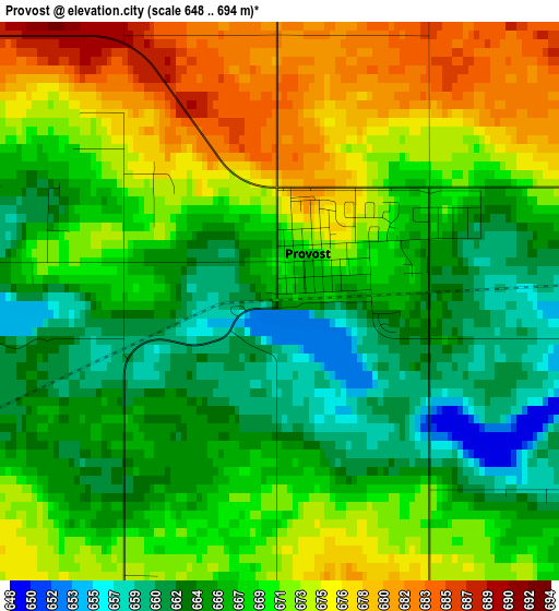
Below is the Elevation map of Provost, which displays elevation range with different colors. Scale of the first map is from 648 to 694 m (2126 to 2277 ft) with average elevation of 669.1 meters (=2195 ft) [note 1]
These maps also provides idea of topography and contour of this city, they are displayed at different zoom levels. More info about maps, scale and edge coordinates you can find below images.
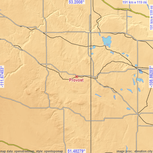
| \ | Map #1 | Topo.Map |
| Scale [m] | 648..694 m | × |
| Scale [ft] | 2126..2277 ft | × |
| Average | 669.1 m = 2195 ft | × |
| Width | 5.97 km = 3.7 mi | 191 km = 118.7 mi |
| Height | 5.97 km = 3.7 mi | 191 km = 118.7 mi |
| ↑Max Latitude | 52.376975° | 53.2008° |
| Latitude at center | 52.35014° | 52.35014° |
| ↓Min Latitude | 52.323289° | 51.48279° |
| ← Min Longitude | -110.312225° | -111.67453° |
| Longitude center | -110.26828° | -110.26828° |
| →Max Longitude | -110.224335° | -108.86203° |
Nearby cities:
Cities around Provost sort by population:
• Lloydminster elevation 652 m
103.9 km,  9°
9°
• North Battleford 526 m
141.6 km,  70°
70°
• Wainwright 680 m
66.8 km,  323°
323°
• Kindersley 689 m
123.9 km,  142°
142°
• Vermilion 617 m
118.5 km,  340°
340°
• Hanna 826 m
137.3 km,  234°
234°
• Unity 633 m
75.5 km,  81°
81°
• Macklin 674 m
22.7 km,  94°
94°
• Wilkie 662 m
106.6 km, 86°
• Viking 683 m
131 km,  309°
309°
• Killam 677 m
117.4 km,  294°
294°
• Kerrobert 685 m
91.1 km,  121°
121°
Multilingual:
 En español:
Provost elevación 666 m.
 En France:
Provost élévation 666 m.


Sources and notes:
- [note 1] Map square and city borders are not equal. Map elevation data is calculated only from area inside that square.
- [src 1] Elevation data from geonames database provided with same terms of usage.
- [src 2] The elevation map of Provost is generated using elevation data from NASA's 3 arcsec (90m) resolution SRTM data.
- [src 3] Base (background) map © OpenStreetMap contributors tiles are generated by Geofabrik and OpenTopoMap.
Copyright & License:
This Provost Elevation Map is licensed under CC BY-SA. You may reuse any part from this page, if you give a proper credit by linking to this URL:
 More info on terms of use page.