Vegreville elevation
Vegreville (Alberta), Canada elevation is 635 meters and Vegreville elevation in feet is 2083 ft above sea level [src 1]. Vegreville is a populated place (feature code) with elevation that is 377 meters (1237 ft) bigger than average city elevation in Canada.
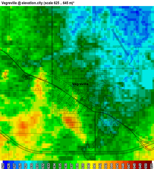
Below is the Elevation map of Vegreville, which displays elevation range with different colors. Scale of the first map is from 625 to 645 m (2051 to 2116 ft) with average elevation of 633.9 meters (=2080 ft) [note 1]
These maps also provides idea of topography and contour of this city, they are displayed at different zoom levels. More info about maps, scale and edge coordinates you can find below images.
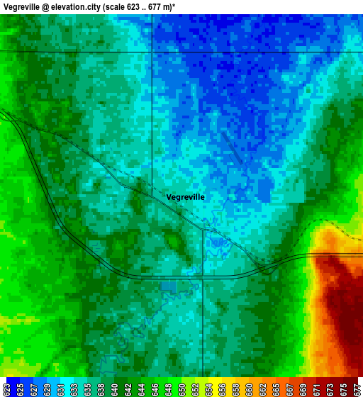
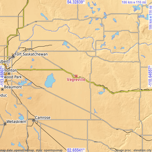
| \ | Map #1 | Map #2 | Topo.Map |
| Scale [m] | 625..645 m | 623..677 m | × |
| Scale [ft] | 2051..2116 ft | 2044..2221 ft | × |
| Average | 633.9 m = 2080 ft | 638.7 m = 2095 ft | × |
| Width | 5.81 km = 3.6 mi | 11.63 km = 7.2 mi | 186 km = 115.6 mi |
| Height | 5.81 km = 3.6 mi | 11.63 km = 7.2 mi | 186 km = 115.6 mi |
| ↑Max Latitude | 53.526282° | 53.552397° | 54.32839° |
| Latitude at center | 53.50015° | 53.50015° | 53.50015° |
| ↓Min Latitude | 53.474002° | 53.447839° | 52.65541° |
| ← Min Longitude | -112.095765° | -112.139711° | -113.45807° |
| Longitude center | -112.05182° | -112.05182° | -112.05182° |
| →Max Longitude | -112.007875° | -111.963929° | -110.64557° |
Nearby cities:
Cities around Vegreville sort by population:
• Sherwood Park elevation 722 m
83.8 km,  271°
271°
• Camrose 739 m
74.9 km,  224°
224°
• Fort Saskatchewan 595 m
80.7 km,  287°
287°
• St. Paul 632 m
73.7 km,  43°
43°
• Vermilion 617 m
80.7 km,  101°
101°
• Tofield 697 m
43.5 km,  250°
250°
• Lamont 643 m
57.7 km,  300°
300°
• Maple Ridge 703 m
86.7 km, 270°
• Two Hills 621 m
31.2 km, 39°
• Viking 683 m
48.3 km,  157°
157°
• Smoky Lake 618 m
73.8 km,  338°
338°
• Killam 677 m
80.8 km,  170°
170°
Multilingual:
 En español:
Vegreville elevación 635 m.
 En France:
Vegreville élévation 635 m.
 Auf Deutsch:
Vegreville höhe über dem Meeresspiegel ist 635 m.

Sources and notes:
- [note 1] Map square and city borders are not equal. Map elevation data is calculated only from area inside that square.
- [src 1] Elevation data from geonames database provided with same terms of usage.
- [src 2] The elevation map of Vegreville is generated using elevation data from NASA's 3 arcsec (90m) resolution SRTM data.
- [src 3] Base (background) map © OpenStreetMap contributors tiles are generated by Geofabrik and OpenTopoMap.
Copyright & License:
This Vegreville Elevation Map is licensed under CC BY-SA. You may reuse any part from this page, if you give a proper credit by linking to this URL:
 More info on terms of use page.