St. Thomas elevation
St. Thomas (Ontario), Canada elevation is 232 meters and St. Thomas elevation in feet is 761 ft above sea level [src 1]. St. Thomas is a populated place (feature code) with elevation that is 26 meters (85 ft) smaller than average city elevation in Canada.
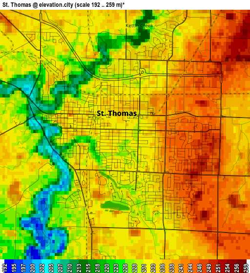
Below is the Elevation map of St. Thomas, which displays elevation range with different colors. Scale of the first map is from 192 to 259 m (630 to 850 ft) with average elevation of 233.2 meters (=765 ft) [note 1]
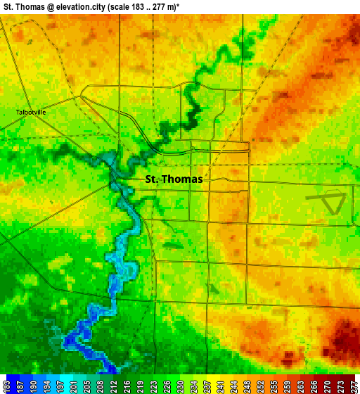
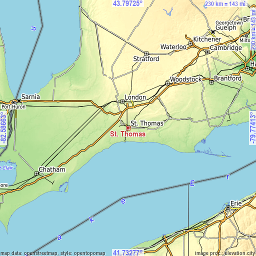
These maps also provides idea of topography and contour of this city, they are displayed at different zoom levels. More info about maps, scale and edge coordinates you can find below images.
| \ | Map #1 | Map #2 | Topo.Map |
| Scale [m] | 192..259 m | 183..277 m | × |
| Scale [ft] | 630..850 ft | 600..909 ft | × |
| Average | 233.2 m = 765 ft | 235.1 m = 771 ft | × |
| Width | 7.17 km = 4.5 mi | 14.35 km = 8.9 mi | 229.5 km = 142.6 mi |
| Height | 7.17 km = 4.5 mi | 14.35 km = 8.9 mi | 229.5 km = 142.6 mi |
| ↑Max Latitude | 42.805859° | 42.838092° | 43.79725° |
| Latitude at center | 42.77361° | 42.77361° | 42.77361° |
| ↓Min Latitude | 42.741344° | 42.709061° | 41.73277° |
| ← Min Longitude | -81.224325° | -81.268271° | -82.58663° |
| Longitude center | -81.18038° | -81.18038° | -81.18038° |
| →Max Longitude | -81.136435° | -81.092489° | -79.77413° |
Nearby cities:
Cities around St. Thomas sort by population:
• London elevation 252 m
23.7 km,  349°
349°
• Woodstock 299 m
53.2 km,  41°
41°
• Ingersoll 293 m
37.7 km, 39°
• Dorchester 260 m
25.1 km,  21°
21°
• Aylmer 229 m
16.1 km,  92°
92°
• Lucan 304 m
48.9 km,  338°
338°
• Delaware 222 m
25 km,  309°
309°
• Port Stanley 180 m
12.2 km,  193°
193°
• Glencoe 223 m
43.8 km,  266°
266°
• Mount Brydges 246 m
28.4 km,  299°
299°
• West Lorne 216 m
39.3 km,  240°
240°
• Belmont 257 m
14.6 km,  33°
33°
Multilingual:
 En español:
Saint Thomas elevación 232 m.
 En France:
St. Thomas élévation 232 m.
 Auf Deutsch:
St. Thomas höhe über dem Meeresspiegel ist 232 m.

Sources and notes:
- [note 1] Map square and city borders are not equal. Map elevation data is calculated only from area inside that square.
- [src 1] Elevation data from geonames database provided with same terms of usage.
- [src 2] The elevation map of St. Thomas is generated using elevation data from NASA's 3 arcsec (90m) resolution SRTM data.
- [src 3] Base (background) map © OpenStreetMap contributors tiles are generated by Geofabrik and OpenTopoMap.
Copyright & License:
This St. Thomas Elevation Map is licensed under CC BY-SA. You may reuse any part from this page, if you give a proper credit by linking to this URL:
 More info on terms of use page.