Ingersoll elevation
Ingersoll (Ontario), Canada elevation is 293 meters and Ingersoll elevation in feet is 961 ft above sea level [src 1]. Ingersoll is a populated place (feature code) with elevation that is 35 meters (115 ft) bigger than average city elevation in Canada.
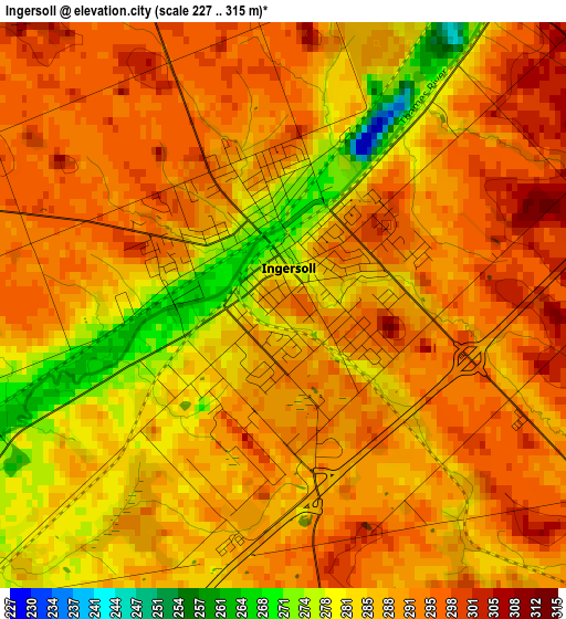
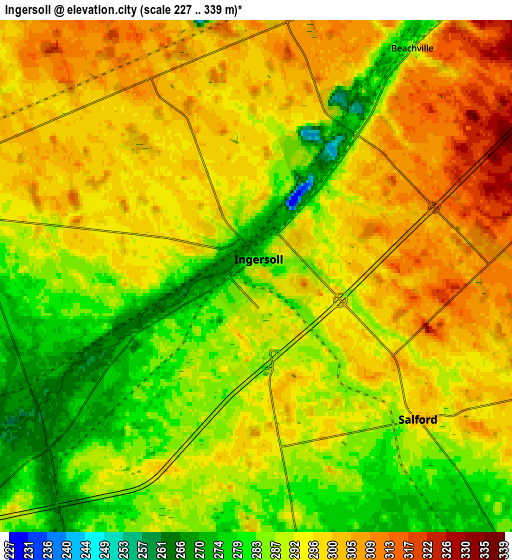
Below is the Elevation map of Ingersoll, which displays elevation range with different colors. Scale of the first map is from 227 to 315 m (745 to 1033 ft) with average elevation of 289 meters (=948 ft) [note 1]
These maps also provides idea of topography and contour of this city, they are displayed at different zoom levels. More info about maps, scale and edge coordinates you can find below images.
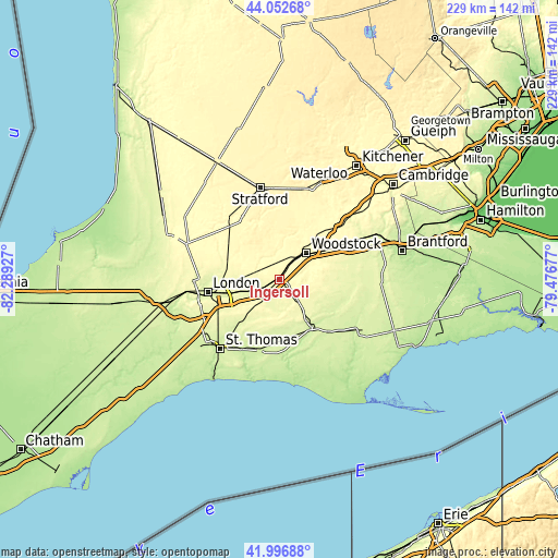
| \ | Map #1 | Map #2 | Topo.Map |
| Scale [m] | 227..315 m | 227..339 m | × |
| Scale [ft] | 745..1033 ft | 745..1112 ft | × |
| Average | 289 m = 948 ft | 292.9 m = 961 ft | × |
| Width | 7.14 km = 4.4 mi | 14.29 km = 8.9 mi | 228.6 km = 142 mi |
| Height | 7.14 km = 4.4 mi | 14.29 km = 8.9 mi | 228.6 km = 142 mi |
| ↑Max Latitude | 43.065504° | 43.097601° | 44.05268° |
| Latitude at center | 43.03339° | 43.03339° | 43.03339° |
| ↓Min Latitude | 43.001259° | 42.969112° | 41.99688° |
| ← Min Longitude | -80.926965° | -80.970911° | -82.28927° |
| Longitude center | -80.88302° | -80.88302° | -80.88302° |
| →Max Longitude | -80.839075° | -80.795129° | -79.47677° |
Nearby cities:
Cities around Ingersoll sort by population:
• London elevation 252 m
29 km,  258°
258°
• Woodstock 299 m
15.5 km,  44°
44°
• St. Thomas 232 m
37.7 km,  219°
219°
• Stratford 365 m
37.5 km,  351°
351°
• New Hamburg 348 m
41.7 km,  20°
20°
• Paris 255 m
44.6 km,  65°
65°
• Dorchester 260 m
15.9 km,  249°
249°
• Aylmer 229 m
30.7 km,  195°
195°
• Tavistock 341 m
31.8 km,  7°
7°
• Burford 258 m
37.7 km,  78°
78°
• Plattsville 302 m
36.7 km, 36°
• Belmont 257 m
23.3 km, 224°
Multilingual:
 En español:
Ingersoll elevación 293 m.
 En France:
Ingersoll élévation 293 m.
 Auf Deutsch:
Ingersoll höhe über dem Meeresspiegel ist 293 m.

Sources and notes:
- [note 1] Map square and city borders are not equal. Map elevation data is calculated only from area inside that square.
- [src 1] Elevation data from geonames database provided with same terms of usage.
- [src 2] The elevation map of Ingersoll is generated using elevation data from NASA's 3 arcsec (90m) resolution SRTM data.
- [src 3] Base (background) map © OpenStreetMap contributors tiles are generated by Geofabrik and OpenTopoMap.
Copyright & License:
This Ingersoll Elevation Map is licensed under CC BY-SA. You may reuse any part from this page, if you give a proper credit by linking to this URL:
 More info on terms of use page.