Stratford elevation
Stratford (Ontario), Canada elevation is 365 meters and Stratford elevation in feet is 1198 ft above sea level [src 1]. Stratford is a populated place (feature code) with elevation that is 107 meters (351 ft) bigger than average city elevation in Canada.
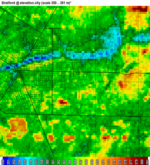
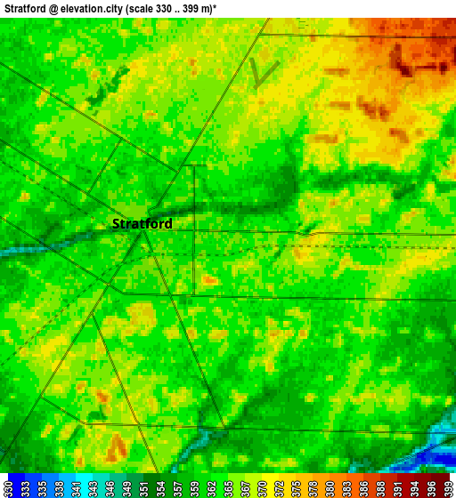
Below is the Elevation map of Stratford, which displays elevation range with different colors. Scale of the first map is from 350 to 381 m (1148 to 1250 ft) with average elevation of 363.8 meters (=1194 ft) [note 1]
These maps also provides idea of topography and contour of this city, they are displayed at different zoom levels. More info about maps, scale and edge coordinates you can find below images.
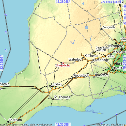
| \ | Map #1 | Map #2 | Topo.Map |
| Scale [m] | 350..381 m | 330..399 m | × |
| Scale [ft] | 1148..1250 ft | 1083..1309 ft | × |
| Average | 363.8 m = 1194 ft | 364.6 m = 1196 ft | × |
| Width | 7.1 km = 4.4 mi | 14.21 km = 8.8 mi | 227.3 km = 141.2 mi |
| Height | 7.1 km = 4.4 mi | 14.21 km = 8.8 mi | 227.3 km = 141.2 mi |
| ↑Max Latitude | 43.398729° | 43.43065° | 44.38048° |
| Latitude at center | 43.36679° | 43.36679° | 43.36679° |
| ↓Min Latitude | 43.334835° | 43.302862° | 42.33588° |
| ← Min Longitude | -80.993665° | -81.037611° | -82.35597° |
| Longitude center | -80.94972° | -80.94972° | -80.94972° |
| →Max Longitude | -80.905775° | -80.861829° | -79.54347° |
Nearby cities:
Cities around Stratford sort by population:
• Kitchener elevation 336 m
36 km,  79°
79°
• Waterloo 325 m
36.7 km,  72°
72°
• Woodstock 299 m
30.6 km,  148°
148°
• New Hamburg 348 m
20.3 km, 84°
• North Perth 380 m
39.9 km,  357°
357°
• Ingersoll 293 m
37.5 km,  171°
171°
• Huron East 338 m
39.6 km,  314°
314°
• Listowel 381 m
40.8 km, 359°
• Wellesley 358 m
19.5 km,  51°
51°
• Tavistock 341 m
11 km,  120°
120°
• Seaforth 308 m
41.6 km,  299°
299°
• Plattsville 302 m
28 km,  105°
105°
Multilingual:
 En español:
Stratford elevación 365 m.
 En France:
Stratford élévation 365 m.
 Auf Deutsch:
Stratford höhe über dem Meeresspiegel ist 365 m.

Sources and notes:
- [note 1] Map square and city borders are not equal. Map elevation data is calculated only from area inside that square.
- [src 1] Elevation data from geonames database provided with same terms of usage.
- [src 2] The elevation map of Stratford is generated using elevation data from NASA's 3 arcsec (90m) resolution SRTM data.
- [src 3] Base (background) map © OpenStreetMap contributors tiles are generated by Geofabrik and OpenTopoMap.
Copyright & License:
This Stratford Elevation Map is licensed under CC BY-SA. You may reuse any part from this page, if you give a proper credit by linking to this URL:
 More info on terms of use page.