Huron East elevation
Huron East (Ontario), Canada elevation is 338 meters and Huron East elevation in feet is 1109 ft above sea level [src 1]. Huron East is a populated place (feature code) with elevation that is 80 meters (262 ft) bigger than average city elevation in Canada.
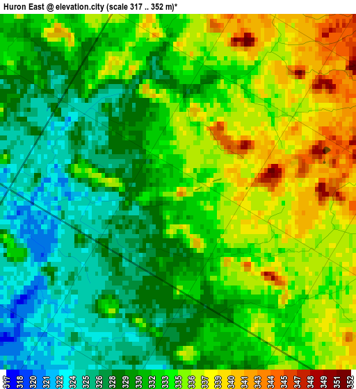
Below is the Elevation map of Huron East, which displays elevation range with different colors. Scale of the first map is from 317 to 352 m (1040 to 1155 ft) with average elevation of 332.2 meters (=1090 ft) [note 1]
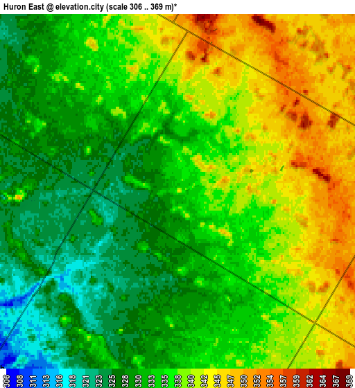
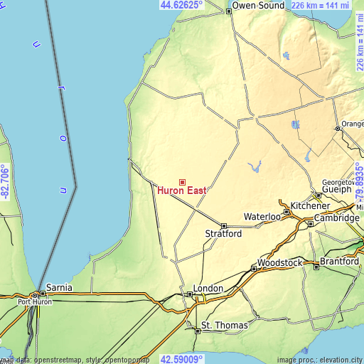
These maps also provides idea of topography and contour of this city, they are displayed at different zoom levels. More info about maps, scale and edge coordinates you can find below images.
| \ | Map #1 | Map #2 | Topo.Map |
| Scale [m] | 317..352 m | 306..369 m | × |
| Scale [ft] | 1040..1155 ft | 1004..1211 ft | × |
| Average | 332.2 m = 1090 ft | 335.2 m = 1100 ft | × |
| Width | 7.07 km = 4.4 mi | 14.15 km = 8.8 mi | 226.4 km = 140.7 mi |
| Height | 7.07 km = 4.4 mi | 14.15 km = 8.8 mi | 226.4 km = 140.7 mi |
| ↑Max Latitude | 43.648597° | 43.680386° | 44.62625° |
| Latitude at center | 43.61679° | 43.61679° | 43.61679° |
| ↓Min Latitude | 43.584967° | 43.553126° | 42.59009° |
| ← Min Longitude | -81.343695° | -81.387641° | -82.706° |
| Longitude center | -81.29975° | -81.29975° | -81.29975° |
| →Max Longitude | -81.255805° | -81.211859° | -79.8935° |
Nearby cities:
Cities around Huron East sort by population:
• Stratford elevation 365 m
39.6 km,  134°
134°
• North Perth 380 m
29.3 km,  65°
65°
• South Huron 246 m
37.7 km,  207°
207°
• Goderich 222 m
36 km,  292°
292°
• Listowel 381 m
31 km, 65°
• Bluewater 249 m
29.4 km,  235°
235°
• Wellesley 358 m
46 km,  109°
109°
• Wingham 318 m
30.2 km,  358°
358°
• Seaforth 308 m
10.9 km,  227°
227°
• Lucan 304 m
48.9 km,  189°
189°
• Harriston 384 m
46 km,  46°
46°
• Brussels 348 m
13.6 km,  17°
17°
Multilingual:
 En español:
Huron East elevación 338 m.
 En France:
Huron East élévation 338 m.
 Auf Deutsch:
Huron East höhe über dem Meeresspiegel ist 338 m.

Sources and notes:
- [note 1] Map square and city borders are not equal. Map elevation data is calculated only from area inside that square.
- [src 1] Elevation data from geonames database provided with same terms of usage.
- [src 2] The elevation map of Huron East is generated using elevation data from NASA's 3 arcsec (90m) resolution SRTM data.
- [src 3] Base (background) map © OpenStreetMap contributors tiles are generated by Geofabrik and OpenTopoMap.
Copyright & License:
This Huron East Elevation Map is licensed under CC BY-SA. You may reuse any part from this page, if you give a proper credit by linking to this URL:
 More info on terms of use page.