Lucan elevation
Lucan (Ontario, Middlesex County), Canada elevation is 304 meters and Lucan elevation in feet is 997 ft above sea level [src 1]. Lucan is a populated place (feature code) with elevation that is 46 meters (151 ft) bigger than average city elevation in Canada.
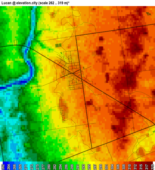
Below is the Elevation map of Lucan, which displays elevation range with different colors. Scale of the first map is from 262 to 319 m (860 to 1047 ft) with average elevation of 297.9 meters (=977 ft) [note 1]
These maps also provides idea of topography and contour of this city, they are displayed at different zoom levels. More info about maps, scale and edge coordinates you can find below images.
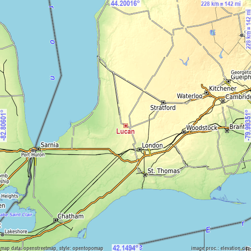
| \ | Map #1 | Topo.Map |
| Scale [m] | 262..319 m | × |
| Scale [ft] | 860..1047 ft | × |
| Average | 297.9 m = 977 ft | × |
| Width | 7.13 km = 4.4 mi | 228 km = 141.7 mi |
| Height | 7.13 km = 4.4 mi | 228 km = 141.7 mi |
| ↑Max Latitude | 43.215425° | 44.20016° |
| Latitude at center | 43.18339° | 43.18339° |
| ↓Min Latitude | 43.151338° | 42.1494° |
| ← Min Longitude | -81.443705° | -82.80601° |
| Longitude center | -81.39976° | -81.39976° |
| →Max Longitude | -81.355815° | -79.99351° |
Nearby cities:
Cities around Lucan sort by population:
• London elevation 252 m
26 km,  148°
148°
• Stratford 365 m
41.8 km,  60°
60°
• Ingersoll 293 m
45.1 km,  111°
111°
• Lambton Shores 207 m
43.3 km,  267°
267°
• South Huron 246 m
17.6 km,  327°
327°
• Dorchester 260 m
35 km,  129°
129°
• Bluewater 249 m
35.4 km, 332°
• Seaforth 308 m
40.8 km,  0°
0°
• Delaware 222 m
29.7 km,  182°
182°
• Mount Brydges 246 m
32.2 km,  192°
192°
• Parkhill 207 m
23.2 km,  263°
263°
• Belmont 257 m
42.1 km,  142°
142°
Multilingual:
 En español:
Lucan elevación 304 m.
 En France:
Lucan élévation 304 m.


Sources and notes:
- [note 1] Map square and city borders are not equal. Map elevation data is calculated only from area inside that square.
- [src 1] Elevation data from geonames database provided with same terms of usage.
- [src 2] The elevation map of Lucan is generated using elevation data from NASA's 3 arcsec (90m) resolution SRTM data.
- [src 3] Base (background) map © OpenStreetMap contributors tiles are generated by Geofabrik and OpenTopoMap.
Copyright & License:
This Lucan Elevation Map is licensed under CC BY-SA. You may reuse any part from this page, if you give a proper credit by linking to this URL:
 More info on terms of use page.