Shaunavon elevation
Shaunavon (Saskatchewan), Canada elevation is 916 meters and Shaunavon elevation in feet is 3005 ft above sea level [src 1]. Shaunavon is a populated place (feature code) with elevation that is 658 meters (2159 ft) bigger than average city elevation in Canada.
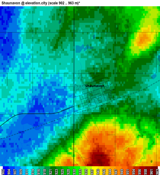
Below is the Elevation map of Shaunavon, which displays elevation range with different colors. Scale of the first map is from 902 to 963 m (2959 to 3159 ft) with average elevation of 921 meters (=3022 ft) [note 1]
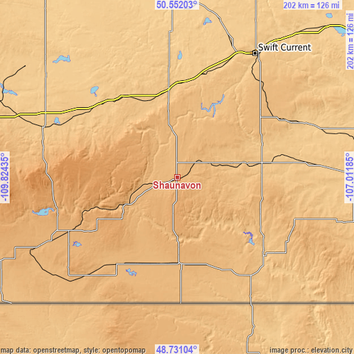
These maps also provides idea of topography and contour of this city, they are displayed at different zoom levels. More info about maps, scale and edge coordinates you can find below images.
| \ | Map #1 | Topo.Map |
| Scale [m] | 902..963 m | × |
| Scale [ft] | 2959..3159 ft | × |
| Average | 921 m = 3022 ft | × |
| Width | 6.33 km = 3.9 mi | 202.5 km = 125.8 mi |
| Height | 6.33 km = 3.9 mi | 202.5 km = 125.8 mi |
| ↑Max Latitude | 49.678494° | 50.55203° |
| Latitude at center | 49.65005° | 49.65005° |
| ↓Min Latitude | 49.621589° | 48.73104° |
| ← Min Longitude | -108.462045° | -109.82435° |
| Longitude center | -108.4181° | -108.4181° |
| →Max Longitude | -108.374155° | -107.01185° |
Nearby cities:
Cities around Shaunavon sort by population:
• Medicine Hat elevation 673 m
167.6 km,  284°
284°
• Moose Jaw 552 m
222.2 km,  67°
67°
• Swift Current 742 m
83.1 km,  32°
32°
• Brooks 748 m
268.1 km,  292°
292°
• Kindersley 689 m
208.8 km,  345°
345°
• Assiniboia 743 m
175.2 km,  90°
90°
• Rosetown 583 m
213.3 km,  7°
7°
• Maple Creek 759 m
82.1 km, 291°
• Bow Island 795 m
213.3 km, 276°
• Outlook 538 m
227.2 km, 25°
• Gravelbourg 699 m
136.6 km,  79°
79°
• Kerrobert 685 m
257 km, 348°
Multilingual:
 En español:
Shaunavon elevación 916 m.
 En France:
Shaunavon élévation 916 m.
 Auf Deutsch:
Shaunavon höhe über dem Meeresspiegel ist 916 m.

Sources and notes:
- [note 1] Map square and city borders are not equal. Map elevation data is calculated only from area inside that square.
- [src 1] Elevation data from geonames database provided with same terms of usage.
- [src 2] The elevation map of Shaunavon is generated using elevation data from NASA's 3 arcsec (90m) resolution SRTM data.
- [src 3] Base (background) map © OpenStreetMap contributors tiles are generated by Geofabrik and OpenTopoMap.
Copyright & License:
This Shaunavon Elevation Map is licensed under CC BY-SA. You may reuse any part from this page, if you give a proper credit by linking to this URL:
 More info on terms of use page.