Moose Jaw elevation
Moose Jaw (Saskatchewan), Canada elevation is 552 meters and Moose Jaw elevation in feet is 1811 ft above sea level [src 1]. Moose Jaw is a populated place (feature code) with elevation that is 294 meters (965 ft) bigger than average city elevation in Canada.
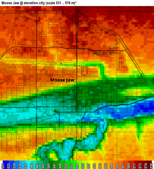
Below is the Elevation map of Moose Jaw, which displays elevation range with different colors. Scale of the first map is from 531 to 576 m (1742 to 1890 ft) with average elevation of 558.1 meters (=1831 ft) [note 1]
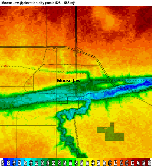
These maps also provides idea of topography and contour of this city, they are displayed at different zoom levels. More info about maps, scale and edge coordinates you can find below images.
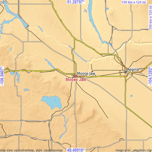
| \ | Map #1 | Map #2 | Topo.Map |
| Scale [m] | 531..576 m | 528..585 m | × |
| Scale [ft] | 1742..1890 ft | 1732..1919 ft | × |
| Average | 558.1 m = 1831 ft | 564.2 m = 1851 ft | × |
| Width | 6.23 km = 3.9 mi | 12.46 km = 7.7 mi | 199.3 km = 123.8 mi |
| Height | 6.23 km = 3.9 mi | 12.46 km = 7.7 mi | 199.3 km = 123.8 mi |
| ↑Max Latitude | 50.428053° | 50.45604° | 51.28797° |
| Latitude at center | 50.40005° | 50.40005° | 50.40005° |
| ↓Min Latitude | 50.37203° | 50.343993° | 49.49518° |
| ← Min Longitude | -105.578395° | -105.622341° | -106.9407° |
| Longitude center | -105.53445° | -105.53445° | -105.53445° |
| →Max Longitude | -105.490505° | -105.446559° | -104.1282° |
Nearby cities:
Cities around Moose Jaw sort by population:
• Regina elevation 577 m
65.2 km,  85°
85°
• Swift Current 742 m
161.4 km,  265°
265°
• Weyburn 568 m
145.3 km,  124°
124°
• Assiniboia 743 m
91.1 km,  200°
200°
• Outlook 538 m
162 km,  319°
319°
• Watrous 543 m
140.9 km,  1°
1°
• White City 606 m
82.7 km, 87°
• Pilot Butte 609 m
79.4 km,  84°
84°
• Indian Head 588 m
132.9 km, 83°
• Regina Beach 531 m
56.9 km,  41°
41°
• Lumsden 496 m
54.7 km,  59°
59°
• Gravelbourg 699 m
92.5 km,  231°
231°
Multilingual:
 En español:
Moose Jaw elevación 552 m.
 En France:
Moose Jaw élévation 552 m.
 Auf Deutsch:
Moose Jaw höhe über dem Meeresspiegel ist 552 m.

Sources and notes:
- [note 1] Map square and city borders are not equal. Map elevation data is calculated only from area inside that square.
- [src 1] Elevation data from geonames database provided with same terms of usage.
- [src 2] The elevation map of Moose Jaw is generated using elevation data from NASA's 3 arcsec (90m) resolution SRTM data.
- [src 3] Base (background) map © OpenStreetMap contributors tiles are generated by Geofabrik and OpenTopoMap.
Copyright & License:
This Moose Jaw Elevation Map is licensed under CC BY-SA. You may reuse any part from this page, if you give a proper credit by linking to this URL:
 More info on terms of use page.