Medicine Hat elevation
Medicine Hat (Alberta), Canada elevation is 673 meters and Medicine Hat elevation in feet is 2208 ft above sea level [src 1]. Medicine Hat is a populated place (feature code) with elevation that is 415 meters (1362 ft) bigger than average city elevation in Canada.
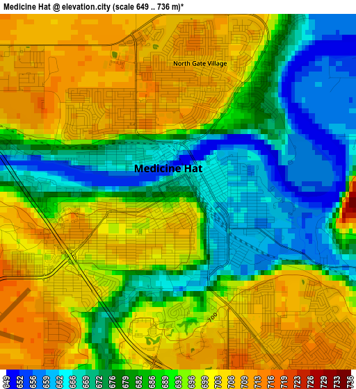
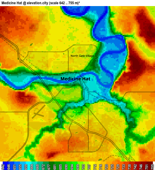
Below is the Elevation map of Medicine Hat, which displays elevation range with different colors. Scale of the first map is from 649 to 736 m (2129 to 2415 ft) with average elevation of 689.7 meters (=2263 ft) [note 1]
These maps also provides idea of topography and contour of this city, they are displayed at different zoom levels. More info about maps, scale and edge coordinates you can find below images.
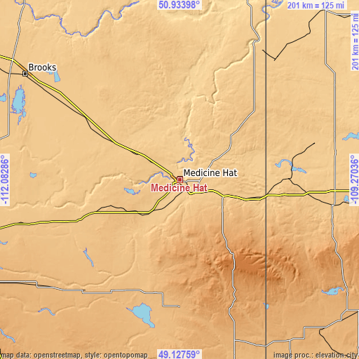
| \ | Map #1 | Map #2 | Topo.Map |
| Scale [m] | 649..736 m | 642..755 m | × |
| Scale [ft] | 2129..2415 ft | 2106..2477 ft | × |
| Average | 689.7 m = 2263 ft | 704.9 m = 2313 ft | × |
| Width | 6.28 km = 3.9 mi | 12.55 km = 7.8 mi | 200.9 km = 124.8 mi |
| Height | 6.28 km = 3.9 mi | 12.55 km = 7.8 mi | 200.8 km = 124.8 mi |
| ↑Max Latitude | 50.067496° | 50.095696° | 50.93398° |
| Latitude at center | 50.03928° | 50.03928° | 50.03928° |
| ↓Min Latitude | 50.011047° | 49.982798° | 49.12759° |
| ← Min Longitude | -110.720555° | -110.764501° | -112.08286° |
| Longitude center | -110.67661° | -110.67661° | -110.67661° |
| →Max Longitude | -110.632665° | -110.588719° | -109.27036° |
Nearby cities:
Cities around Medicine Hat sort by population:
• Lethbridge elevation 907 m
158.1 km,  256°
256°
• Brooks 748 m
105 km,  305°
305°
• Taber 813 m
108.9 km, 255°
• Coaldale 865 m
143.7 km, 255°
• Raymond 964 m
156.3 km,  245°
245°
• Maple Creek 759 m
86.3 km,  99°
99°
• Bow Island 795 m
53.1 km, 248°
• Picture Butte 906 m
151.8 km, 263°
• Shaunavon 916 m
167.6 km, 104°
• Coalhurst 933 m
164.8 km, 258°
• Bassano 790 m
151.5 km,  303°
303°
• Vauxhall 780 m
103 km,  271°
271°
Multilingual:
 En español:
Medicine Hat elevación 673 m.
 En France:
Medicine Hat élévation 673 m.
 Auf Deutsch:
Medicine Hat höhe über dem Meeresspiegel ist 673 m.

Sources and notes:
- [note 1] Map square and city borders are not equal. Map elevation data is calculated only from area inside that square.
- [src 1] Elevation data from geonames database provided with same terms of usage.
- [src 2] The elevation map of Medicine Hat is generated using elevation data from NASA's 3 arcsec (90m) resolution SRTM data.
- [src 3] Base (background) map © OpenStreetMap contributors tiles are generated by Geofabrik and OpenTopoMap.
Copyright & License:
This Medicine Hat Elevation Map is licensed under CC BY-SA. You may reuse any part from this page, if you give a proper credit by linking to this URL:
 More info on terms of use page.