Orangeville elevation
Orangeville (Ontario), Canada elevation is 443 meters and Orangeville elevation in feet is 1453 ft above sea level [src 1]. Orangeville is a populated place (feature code) with elevation that is 185 meters (607 ft) bigger than average city elevation in Canada.
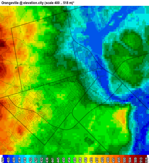
Below is the Elevation map of Orangeville, which displays elevation range with different colors. Scale of the first map is from 400 to 518 m (1312 to 1699 ft) with average elevation of 446.4 meters (=1465 ft) [note 1]
These maps also provides idea of topography and contour of this city, they are displayed at different zoom levels. More info about maps, scale and edge coordinates you can find below images.
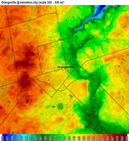
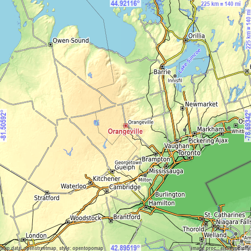
| \ | Map #1 | Map #2 | Topo.Map |
| Scale [m] | 400..518 m | 329..530 m | × |
| Scale [ft] | 1312..1699 ft | 1079..1739 ft | × |
| Average | 446.4 m = 1465 ft | 452.7 m = 1485 ft | × |
| Width | 7.04 km = 4.4 mi | 14.08 km = 8.7 mi | 225.3 km = 140 mi |
| Height | 7.04 km = 4.4 mi | 14.08 km = 8.7 mi | 225.3 km = 140 mi |
| ↑Max Latitude | 43.948447° | 43.980078° | 44.92116° |
| Latitude at center | 43.9168° | 43.9168° | 43.9168° |
| ↓Min Latitude | 43.885136° | 43.853455° | 42.89519° |
| ← Min Longitude | -80.143615° | -80.187561° | -81.50592° |
| Longitude center | -80.09967° | -80.09967° | -80.09967° |
| →Max Longitude | -80.055725° | -80.011779° | -78.69342° |
Nearby cities:
Cities around Orangeville sort by population:
• Brampton elevation 221 m
37.3 km,  134°
134°
• Vaughan 218 m
49 km,  100°
100°
• Guelph 335 m
43.1 km,  196°
196°
• Milton 194 m
47.8 km,  158°
158°
• Alliston 223 m
32 km,  35°
35°
• Angus 193 m
47.7 km,  21°
21°
• Concord 188 m
51.1 km, 104°
• Shelburne 497 m
19.8 km,  335°
335°
• King 311 m
41.1 km,  82°
82°
• Tottenham 247 m
26.4 km,  63°
63°
• Rockwood 360 m
33.3 km,  186°
186°
• Cookstown 237 m
43.6 km,  47°
47°
Multilingual:
 En español:
Orangeville elevación 443 m.
 En France:
Orangeville élévation 443 m.
 Auf Deutsch:
Orangeville höhe über dem Meeresspiegel ist 443 m.

Sources and notes:
- [note 1] Map square and city borders are not equal. Map elevation data is calculated only from area inside that square.
- [src 1] Elevation data from geonames database provided with same terms of usage.
- [src 2] The elevation map of Orangeville is generated using elevation data from NASA's 3 arcsec (90m) resolution SRTM data.
- [src 3] Base (background) map © OpenStreetMap contributors tiles are generated by Geofabrik and OpenTopoMap.
Copyright & License:
This Orangeville Elevation Map is licensed under CC BY-SA. You may reuse any part from this page, if you give a proper credit by linking to this URL:
 More info on terms of use page.