Vaughan elevation
Vaughan (Ontario), Canada elevation is 218 meters and Vaughan elevation in feet is 715 ft above sea level [src 1]. Vaughan is a populated place (feature code) with elevation that is 40 meters (131 ft) smaller than average city elevation in Canada.
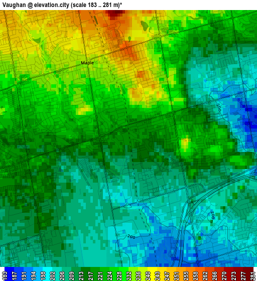
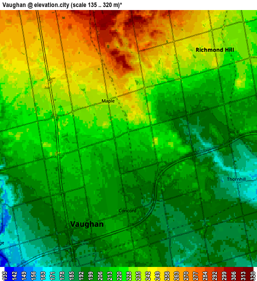
Below is the Elevation map of Vaughan, which displays elevation range with different colors. Scale of the first map is from 183 to 281 m (600 to 922 ft) with average elevation of 217.7 meters (=714 ft) [note 1]
These maps also provides idea of topography and contour of this city, they are displayed at different zoom levels. More info about maps, scale and edge coordinates you can find below images.
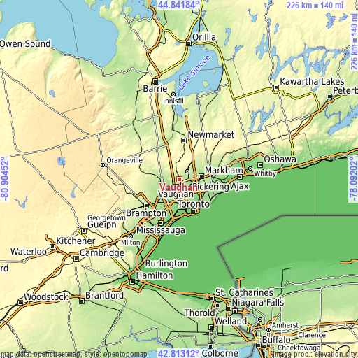
| \ | Map #1 | Map #2 | Topo.Map |
| Scale [m] | 183..281 m | 135..320 m | × |
| Scale [ft] | 600..922 ft | 443..1050 ft | × |
| Average | 217.7 m = 714 ft | 218.8 m = 718 ft | × |
| Width | 7.05 km = 4.4 mi | 14.1 km = 8.8 mi | 225.6 km = 140.2 mi |
| Height | 7.05 km = 4.4 mi | 14.1 km = 8.8 mi | 225.6 km = 140.2 mi |
| ↑Max Latitude | 43.86779° | 43.899464° | 44.84184° |
| Latitude at center | 43.8361° | 43.8361° | 43.8361° |
| ↓Min Latitude | 43.804393° | 43.772669° | 42.81312° |
| ← Min Longitude | -79.542215° | -79.586161° | -80.90452° |
| Longitude center | -79.49827° | -79.49827° | -79.49827° |
| →Max Longitude | -79.454325° | -79.410379° | -78.09202° |
Nearby cities:
Cities around Vaughan sort by population:
• Toronto elevation 175 m
16.5 km,  156°
156°
• North York 178 m
10.1 km,  139°
139°
• Scarborough 171 m
20.6 km,  110°
110°
• Etobicoke 148 m
21 km,  195°
195°
• Markham 168 m
18.9 km,  79°
79°
• Richmond Hill 232 m
6.3 km,  51°
51°
• East York 125 m
21.2 km, 139°
• Willowdale 176 m
11.1 km,  134°
134°
• Newmarket 250 m
23.9 km,  6°
6°
• Aurora 266 m
18.4 km, 7°
• Concord 188 m
4.2 km, 162°
• King 311 m
16.1 km,  332°
332°
Multilingual:
 En español:
Vaughan elevación 218 m.
 En France:
Vaughan élévation 218 m.


Sources and notes:
- [note 1] Map square and city borders are not equal. Map elevation data is calculated only from area inside that square.
- [src 1] Elevation data from geonames database provided with same terms of usage.
- [src 2] The elevation map of Vaughan is generated using elevation data from NASA's 3 arcsec (90m) resolution SRTM data.
- [src 3] Base (background) map © OpenStreetMap contributors tiles are generated by Geofabrik and OpenTopoMap.
Copyright & License:
This Vaughan Elevation Map is licensed under CC BY-SA. You may reuse any part from this page, if you give a proper credit by linking to this URL:
 More info on terms of use page.