Moosonee elevation
Moosonee (Ontario, Cochrane District), Canada elevation is 10 meters and Moosonee elevation in feet is 33 ft above sea level [src 1]. Moosonee is a populated place (feature code) with elevation that is 248 meters (814 ft) smaller than average city elevation in Canada.
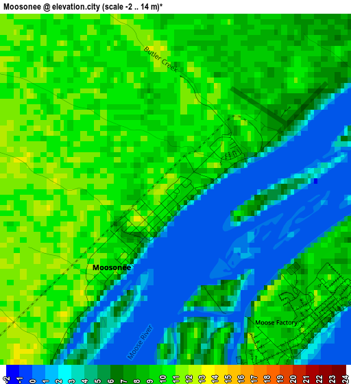
Below is the Elevation map of Moosonee, which displays elevation range with different colors. Scale of the first map is from -2 to 14 m (-7 to 46 ft) with average elevation of 7 meters (=23 ft) [note 1]
These maps also provides idea of topography and contour of this city, they are displayed at different zoom levels. More info about maps, scale and edge coordinates you can find below images.
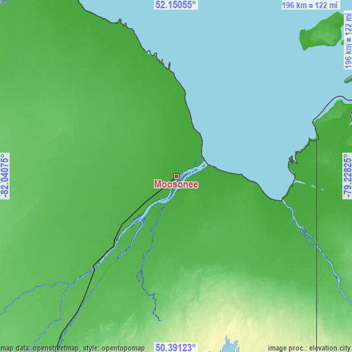
| \ | Map #1 | Topo.Map |
| Scale [m] | -2..14 m | × |
| Scale [ft] | -7..46 ft | × |
| Average | 7 m = 23 ft | × |
| Width | 6.11 km = 3.8 mi | 195.6 km = 121.5 mi |
| Height | 6.11 km = 3.8 mi | 195.6 km = 121.5 mi |
| ↑Max Latitude | 51.306791° | 52.15055° |
| Latitude at center | 51.27931° | 51.27931° |
| ↓Min Latitude | 51.251813° | 50.39123° |
| ← Min Longitude | -80.678445° | -82.04075° |
| Longitude center | -80.6345° | -80.6345° |
| →Max Longitude | -80.590555° | -79.22825° |
Nearby cities:
Cities around Moosonee sort by population:
• Timmins elevation 301 m
316.7 km,  189°
189°
• Amos 298 m
351.3 km,  149°
149°
• Kapuskasing 219 m
243.2 km,  211°
211°
• Kirkland Lake 321 m
351.2 km,  172°
172°
• La Sarre 269 m
294.1 km,  159°
159°
• Hearst 235 m
278.4 km,  230°
230°
• Iroquois Falls 280 m
279.4 km,  180°
180°
• Matagami 257 m
271.9 km,  128°
128°
• Waskaganish 21 m
132.7 km,  80°
80°
• Moose Factory 0 m
1.9 km,  137°
137°
• Macamic 283 m
304.5 km, 157°
• Attawapiskat 5 m
220 km,  326°
326°
Multilingual:
 En español:
Moosonee elevación 10 m.
 En France:
Moosonee élévation 10 m.


Sources and notes:
- [note 1] Map square and city borders are not equal. Map elevation data is calculated only from area inside that square.
- [src 1] Elevation data from geonames database provided with same terms of usage.
- [src 2] The elevation map of Moosonee is generated using elevation data from NASA's 3 arcsec (90m) resolution SRTM data.
- [src 3] Base (background) map © OpenStreetMap contributors tiles are generated by Geofabrik and OpenTopoMap.
Copyright & License:
This Moosonee Elevation Map is licensed under CC BY-SA. You may reuse any part from this page, if you give a proper credit by linking to this URL:
 More info on terms of use page.