Kapuskasing elevation
Kapuskasing (Ontario, Cochrane District), Canada elevation is 219 meters and Kapuskasing elevation in feet is 719 ft above sea level [src 1]. Kapuskasing is a populated place (feature code) with elevation that is 39 meters (128 ft) smaller than average city elevation in Canada.
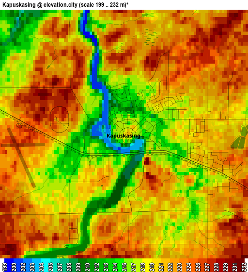
Below is the Elevation map of Kapuskasing, which displays elevation range with different colors. Scale of the first map is from 199 to 232 m (653 to 761 ft) with average elevation of 220.5 meters (=723 ft) [note 1]
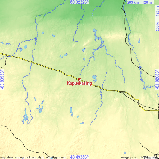
These maps also provides idea of topography and contour of this city, they are displayed at different zoom levels. More info about maps, scale and edge coordinates you can find below images.

| \ | Map #1 | Map #2 | Topo.Map |
| Scale [m] | 199..232 m | 198..253 m | × |
| Scale [ft] | 653..761 ft | 650..830 ft | × |
| Average | 220.5 m = 723 ft | 223.8 m = 734 ft | × |
| Width | 6.36 km = 4 mi | 12.72 km = 7.9 mi | 203.4 km = 126.4 mi |
| Height | 6.36 km = 4 mi | 12.72 km = 7.9 mi | 203.4 km = 126.4 mi |
| ↑Max Latitude | 49.44552° | 49.474084° | 50.32326° |
| Latitude at center | 49.41694° | 49.41694° | 49.41694° |
| ↓Min Latitude | 49.388343° | 49.359729° | 48.49356° |
| ← Min Longitude | -82.477025° | -82.520971° | -83.83933° |
| Longitude center | -82.43308° | -82.43308° | -82.43308° |
| →Max Longitude | -82.389135° | -82.345189° | -81.02683° |
Nearby cities:
Cities around Kapuskasing sort by population:
• Timmins elevation 301 m
132.7 km,  142°
142°
• Kirkland Lake 321 m
225.4 km,  128°
128°
• La Sarre 269 m
245.1 km,  106°
106°
• Hearst 235 m
93.8 km,  288°
288°
• Iroquois Falls 280 m
146.5 km,  119°
119°
• Wawa 287 m
233.9 km,  227°
227°
• Moose Factory 0 m
242.7 km,  32°
32°
• Manitouwadge 331 m
249.4 km,  262°
262°
• Englehart 201 m
259.3 km, 133°
• Macamic 283 m
260.8 km, 106°
• Moosonee 10 m
243.2 km, 31°
• Hornepayne 330 m
171.3 km, 262°
Multilingual:
 En español:
Kapuskasing elevación 219 m.
 En France:
Kapuskasing élévation 219 m.
 Auf Deutsch:
Kapuskasing höhe über dem Meeresspiegel ist 219 m.

Sources and notes:
- [note 1] Map square and city borders are not equal. Map elevation data is calculated only from area inside that square.
- [src 1] Elevation data from geonames database provided with same terms of usage.
- [src 2] The elevation map of Kapuskasing is generated using elevation data from NASA's 3 arcsec (90m) resolution SRTM data.
- [src 3] Base (background) map © OpenStreetMap contributors tiles are generated by Geofabrik and OpenTopoMap.
Copyright & License:
This Kapuskasing Elevation Map is licensed under CC BY-SA. You may reuse any part from this page, if you give a proper credit by linking to this URL:
 More info on terms of use page.