Magog elevation
Magog (Quebec, Estrie), Canada elevation is 220 meters and Magog elevation in feet is 722 ft above sea level [src 1]. Magog is a populated place (feature code) with elevation that is 38 meters (125 ft) smaller than average city elevation in Canada.
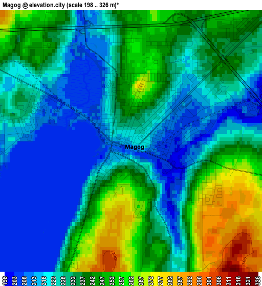
Below is the Elevation map of Magog, which displays elevation range with different colors. Scale of the first map is from 198 to 326 m (650 to 1070 ft) with average elevation of 233.6 meters (=766 ft) [note 1]
These maps also provides idea of topography and contour of this city, they are displayed at different zoom levels. More info about maps, scale and edge coordinates you can find below images.
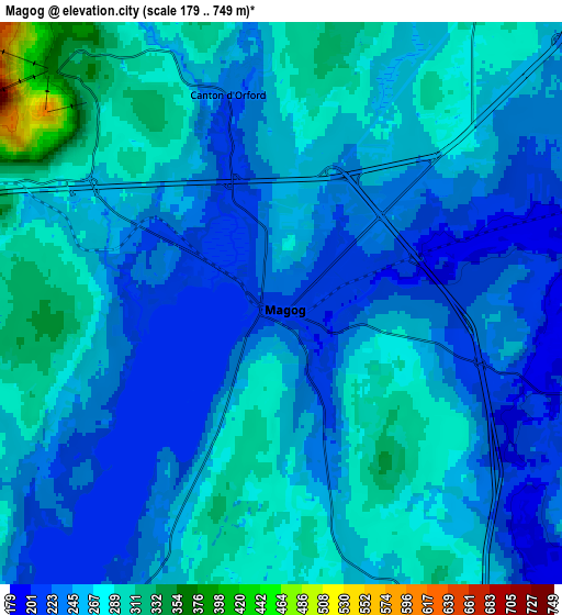
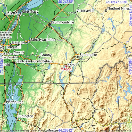
| \ | Map #1 | Map #2 | Topo.Map |
| Scale [m] | 198..326 m | 179..749 m | × |
| Scale [ft] | 650..1070 ft | 587..2457 ft | × |
| Average | 233.6 m = 766 ft | 256.3 m = 841 ft | × |
| Width | 6.88 km = 4.3 mi | 13.76 km = 8.6 mi | 220.1 km = 136.8 mi |
| Height | 6.88 km = 4.3 mi | 13.76 km = 8.6 mi | 220.1 km = 136.8 mi |
| ↑Max Latitude | 45.297701° | 45.328604° | 46.24788° |
| Latitude at center | 45.26678° | 45.26678° | 45.26678° |
| ↓Min Latitude | 45.235843° | 45.204888° | 44.26842° |
| ← Min Longitude | -72.193035° | -72.236981° | -73.55534° |
| Longitude center | -72.14909° | -72.14909° | -72.14909° |
| →Max Longitude | -72.105145° | -72.061199° | -70.74284° |
Nearby cities:
Cities around Magog sort by population:
• Sherbrooke elevation 175 m
24.5 km,  52°
52°
• Rock Forest 240 m
15.6 km, 49°
• Coaticook 289 m
31.2 km,  118°
118°
• Lac-Brome 209 m
29.2 km,  259°
259°
• Windsor 173 m
35.4 km,  19°
19°
• Waterloo 210 m
30.1 km,  287°
287°
• Bromont 126 m
39.5 km,  278°
278°
• Sutton 176 m
41 km,  243°
243°
• Richmond 126 m
44.5 km,  359°
359°
• Valcourt 200 m
29 km,  333°
333°
• Cookshire-Eaton 239 m
43.7 km,  67°
67°
• Cookshire 237 m
43.8 km, 67°
Multilingual:
 En español:
Magog elevación 220 m.
 En France:
Magog élévation 220 m.


Sources and notes:
- [note 1] Map square and city borders are not equal. Map elevation data is calculated only from area inside that square.
- [src 1] Elevation data from geonames database provided with same terms of usage.
- [src 2] The elevation map of Magog is generated using elevation data from NASA's 3 arcsec (90m) resolution SRTM data.
- [src 3] Base (background) map © OpenStreetMap contributors tiles are generated by Geofabrik and OpenTopoMap.
Copyright & License:
This Magog Elevation Map is licensed under CC BY-SA. You may reuse any part from this page, if you give a proper credit by linking to this URL:
 More info on terms of use page.