Valcourt elevation
Valcourt (Quebec, Estrie), Canada elevation is 200 meters and Valcourt elevation in feet is 656 ft above sea level [src 1]. Valcourt is a populated place (feature code) with elevation that is 58 meters (190 ft) smaller than average city elevation in Canada.
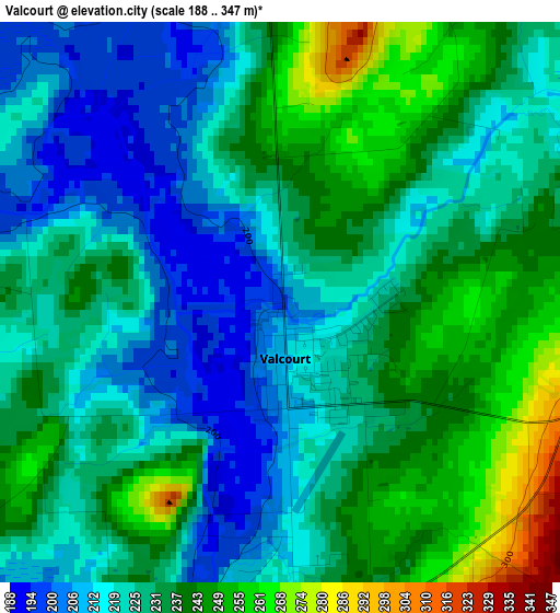
Below is the Elevation map of Valcourt, which displays elevation range with different colors. Scale of the first map is from 188 to 347 m (617 to 1138 ft) with average elevation of 229.6 meters (=753 ft) [note 1]
These maps also provides idea of topography and contour of this city, they are displayed at different zoom levels. More info about maps, scale and edge coordinates you can find below images.
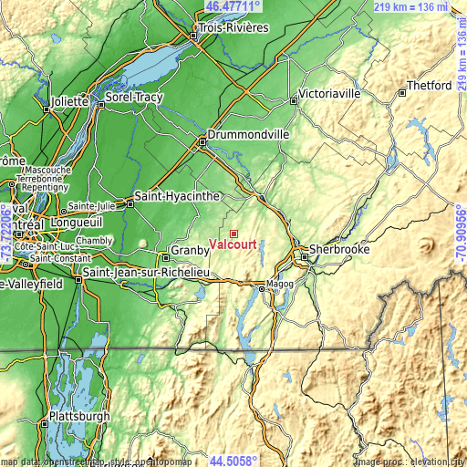
| \ | Map #1 | Topo.Map |
| Scale [m] | 188..347 m | × |
| Scale [ft] | 617..1138 ft | × |
| Average | 229.6 m = 753 ft | × |
| Width | 6.85 km = 4.3 mi | 219.2 km = 136.2 mi |
| Height | 6.85 km = 4.3 mi | 219.2 km = 136.2 mi |
| ↑Max Latitude | 45.530873° | 46.47711° |
| Latitude at center | 45.50008° | 45.50008° |
| ↓Min Latitude | 45.46927° | 44.5058° |
| ← Min Longitude | -72.359755° | -73.72206° |
| Longitude center | -72.31581° | -72.31581° |
| →Max Longitude | -72.271865° | -70.90956° |
Nearby cities:
Cities around Valcourt sort by population:
• Sherbrooke elevation 175 m
34.4 km,  108°
108°
• Granby 102 m
34.3 km,  251°
251°
• Rock Forest 240 m
29.5 km,  122°
122°
• Magog 220 m
29 km,  153°
153°
• Lac-Brome 209 m
35.2 km,  206°
206°
• Windsor 173 m
25.8 km,  73°
73°
• Acton Vale 90 m
25.6 km,  310°
310°
• Waterloo 210 m
22.8 km,  223°
223°
• Bromont 126 m
33.1 km,  231°
231°
• Richmond 126 m
22.6 km,  34°
34°
• Saint-Liboire 82 m
38.7 km,  295°
295°
• Danville 160 m
39.2 km,  36°
36°
Multilingual:
 En español:
Valcourt elevación 200 m.
 En France:
Valcourt élévation 200 m.
 Auf Deutsch:
Valcourt höhe über dem Meeresspiegel ist 200 m.

Sources and notes:
- [note 1] Map square and city borders are not equal. Map elevation data is calculated only from area inside that square.
- [src 1] Elevation data from geonames database provided with same terms of usage.
- [src 2] The elevation map of Valcourt is generated using elevation data from NASA's 3 arcsec (90m) resolution SRTM data.
- [src 3] Base (background) map © OpenStreetMap contributors tiles are generated by Geofabrik and OpenTopoMap.
Copyright & License:
This Valcourt Elevation Map is licensed under CC BY-SA. You may reuse any part from this page, if you give a proper credit by linking to this URL:
 More info on terms of use page.