Ladysmith elevation
Ladysmith (British Columbia, Cowichan Valley Regional District), Canada elevation is 71 meters and Ladysmith elevation in feet is 233 ft above sea level [src 1]. Ladysmith is a populated place (feature code) with elevation that is 187 meters (614 ft) smaller than average city elevation in Canada.
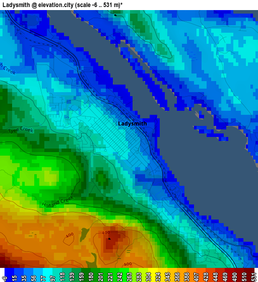
Below is the Elevation map of Ladysmith, which displays elevation range with different colors. Scale of the first map is from -6 to 531 m (-20 to 1742 ft) with average elevation of 139.2 meters (=457 ft) [note 1]
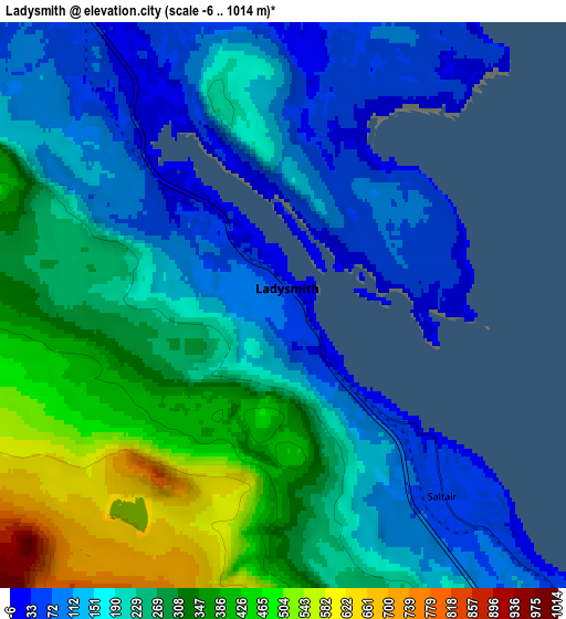
These maps also provides idea of topography and contour of this city, they are displayed at different zoom levels. More info about maps, scale and edge coordinates you can find below images.
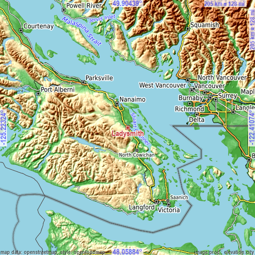
| \ | Map #1 | Map #2 | Topo.Map |
| Scale [m] | -6..531 m | -6..1014 m | × |
| Scale [ft] | -20..1742 ft | -20..3327 ft | × |
| Average | 139.2 m = 457 ft | 234.3 m = 769 ft | × |
| Width | 6.41 km = 4 mi | 12.83 km = 8 mi | 205.2 km = 127.5 mi |
| Height | 6.41 km = 4 mi | 12.83 km = 8 mi | 205.2 km = 127.5 mi |
| ↑Max Latitude | 49.018988° | 49.047799° | 49.90439° |
| Latitude at center | 48.99016° | 48.99016° | 48.99016° |
| ↓Min Latitude | 48.961315° | 48.932454° | 48.05884° |
| ← Min Longitude | -123.860935° | -123.904881° | -125.22324° |
| Longitude center | -123.81699° | -123.81699° | -123.81699° |
| →Max Longitude | -123.773045° | -123.729099° | -122.41074° |
Nearby cities:
Cities around Ladysmith sort by population:
• Nanaimo elevation 16 m
21.5 km,  335°
335°
• North Cowichan 145 m
19.1 km,  149°
149°
• Duncan 14 m
24.5 km,  160°
160°
• Salt Spring Island 122 m
30.5 km,  128°
128°
• Chemainus 40 m
10.9 km,  139°
139°
• Lake Cowichan 167 m
25.3 km,  223°
223°
• Cedar 32 m
14.3 km,  349°
349°
• Cowichan Bay 92 m
32 km, 152°
• Saltair 67 m
5.7 km, 142°
• East Wellington 133 m
25.1 km,  324°
324°
• North Oyster/Yellow Point 58 m
6.6 km, 349°
• Fairwinds 22 m
39 km, 324°
Multilingual:
 En español:
Ladysmith elevación 71 m.
 En France:
Ladysmith élévation 71 m.
 Auf Deutsch:
Ladysmith höhe über dem Meeresspiegel ist 71 m.

Sources and notes:
- [note 1] Map square and city borders are not equal. Map elevation data is calculated only from area inside that square.
- [src 1] Elevation data from geonames database provided with same terms of usage.
- [src 2] The elevation map of Ladysmith is generated using elevation data from NASA's 3 arcsec (90m) resolution SRTM data.
- [src 3] Base (background) map © OpenStreetMap contributors tiles are generated by Geofabrik and OpenTopoMap.
Copyright & License:
This Ladysmith Elevation Map is licensed under CC BY-SA. You may reuse any part from this page, if you give a proper credit by linking to this URL:
 More info on terms of use page.