Duncan elevation
Duncan (British Columbia, Cowichan Valley Regional District), Canada elevation is 14 meters and Duncan elevation in feet is 46 ft above sea level [src 1]. Duncan is a populated place (feature code) with elevation that is 244 meters (801 ft) smaller than average city elevation in Canada.
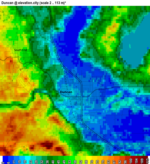
Below is the Elevation map of Duncan, which displays elevation range with different colors. Scale of the first map is from 2 to 113 m (7 to 371 ft) with average elevation of 38.7 meters (=127 ft) [note 1]
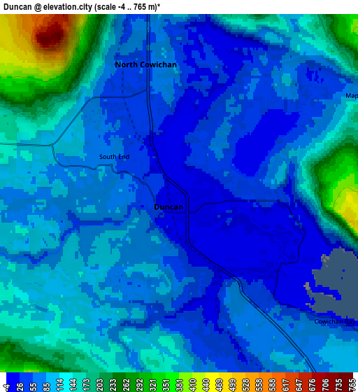
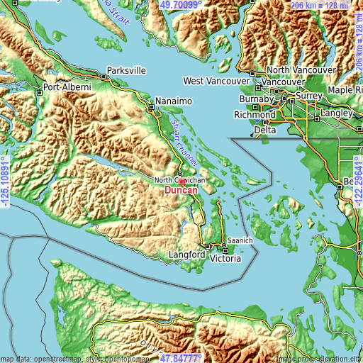
These maps also provides idea of topography and contour of this city, they are displayed at different zoom levels. More info about maps, scale and edge coordinates you can find below images.
| \ | Map #1 | Map #2 | Topo.Map |
| Scale [m] | 2..113 m | -4..765 m | × |
| Scale [ft] | 7..371 ft | -13..2510 ft | × |
| Average | 38.7 m = 127 ft | 99.8 m = 327 ft | × |
| Width | 6.44 km = 4 mi | 12.88 km = 8 mi | 206.1 km = 128.1 mi |
| Height | 6.44 km = 4 mi | 12.88 km = 8 mi | 206 km = 128 mi |
| ↑Max Latitude | 48.811878° | 48.840809° | 49.70099° |
| Latitude at center | 48.78293° | 48.78293° | 48.78293° |
| ↓Min Latitude | 48.753965° | 48.724984° | 47.84777° |
| ← Min Longitude | -123.746605° | -123.790551° | -125.10891° |
| Longitude center | -123.70266° | -123.70266° | -123.70266° |
| →Max Longitude | -123.658715° | -123.614769° | -122.29641° |
Nearby cities:
Cities around Duncan sort by population:
• North Cowichan elevation 145 m
6.6 km,  10°
10°
• Langford 80 m
39.9 km,  158°
158°
• North Saanich 11 m
24.5 km,  121°
121°
• Salt Spring Island 122 m
16 km,  75°
75°
• Ladysmith 71 m
24.5 km,  340°
340°
• Chemainus 40 m
14.9 km,  355°
355°
• Lake Cowichan 167 m
26.2 km,  280°
280°
• Cedar 32 m
38.7 km, 343°
• Cowichan Bay 92 m
8.3 km,  131°
131°
• Saltair 67 m
19.2 km,  345°
345°
• North Oyster/Yellow Point 58 m
31 km, 341°
• Six Mile 25 m
40.3 km,  153°
153°
Multilingual:
 En español:
Duncan elevación 14 m.
 En France:
Duncan élévation 14 m.


Sources and notes:
- [note 1] Map square and city borders are not equal. Map elevation data is calculated only from area inside that square.
- [src 1] Elevation data from geonames database provided with same terms of usage.
- [src 2] The elevation map of Duncan is generated using elevation data from NASA's 3 arcsec (90m) resolution SRTM data.
- [src 3] Base (background) map © OpenStreetMap contributors tiles are generated by Geofabrik and OpenTopoMap.
Copyright & License:
This Duncan Elevation Map is licensed under CC BY-SA. You may reuse any part from this page, if you give a proper credit by linking to this URL:
 More info on terms of use page.