Langford elevation
Langford (British Columbia, Capital Regional District), Canada elevation is 80 meters and Langford elevation in feet is 262 ft above sea level [src 1]. Langford is a populated place (feature code) with elevation that is 178 meters (584 ft) smaller than average city elevation in Canada.
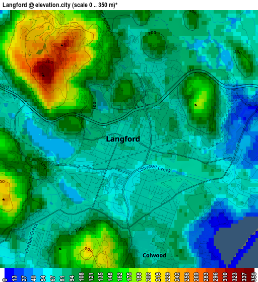
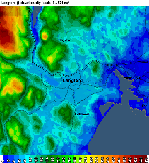
Below is the Elevation map of Langford, which displays elevation range with different colors. Scale of the first map is from 0 to 350 m (0 to 1148 ft) with average elevation of 103.3 meters (=339 ft) [note 1]
These maps also provides idea of topography and contour of this city, they are displayed at different zoom levels. More info about maps, scale and edge coordinates you can find below images.
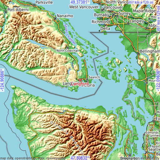
| \ | Map #1 | Map #2 | Topo.Map |
| Scale [m] | 0..350 m | -3..571 m | × |
| Scale [ft] | 0..1148 ft | -10..1873 ft | × |
| Average | 103.3 m = 339 ft | 135.2 m = 444 ft | × |
| Width | 6.48 km = 4 mi | 12.96 km = 8.1 mi | 207.4 km = 128.9 mi |
| Height | 6.48 km = 4 mi | 12.96 km = 8.1 mi | 207.4 km = 128.9 mi |
| ↑Max Latitude | 48.47877° | 48.507892° | 49.37381° |
| Latitude at center | 48.44963° | 48.44963° | 48.44963° |
| ↓Min Latitude | 48.420474° | 48.391301° | 47.50832° |
| ← Min Longitude | -123.546555° | -123.590501° | -124.90886° |
| Longitude center | -123.50261° | -123.50261° | -123.50261° |
| →Max Longitude | -123.458665° | -123.414719° | -122.09636° |
Nearby cities:
Cities around Langford sort by population:
• Victoria elevation 41 m
11.2 km,  97°
97°
• North Cowichan 145 m
45.6 km,  342°
342°
• Duncan 14 m
39.9 km, 338°
• Oak Bay 45 m
14.8 km,  89°
89°
• Colwood 95 m
2.2 km,  146°
146°
• North Saanich 11 m
24.9 km,  14°
14°
• Salt Spring Island 122 m
41 km,  1°
1°
• Sooke 39 m
18.6 km,  243°
243°
• Metchosin 49 m
7.8 km,  198°
198°
• Chemainus 40 m
54.3 km, 342°
• Cowichan Bay 92 m
32.7 km,  345°
345°
• Six Mile 25 m
3.2 km,  73°
73°
Multilingual:
 En español:
Langford elevación 80 m.
 En France:
Langford élévation 80 m.


Sources and notes:
- [note 1] Map square and city borders are not equal. Map elevation data is calculated only from area inside that square.
- [src 1] Elevation data from geonames database provided with same terms of usage.
- [src 2] The elevation map of Langford is generated using elevation data from NASA's 3 arcsec (90m) resolution SRTM data.
- [src 3] Base (background) map © OpenStreetMap contributors tiles are generated by Geofabrik and OpenTopoMap.
Copyright & License:
This Langford Elevation Map is licensed under CC BY-SA. You may reuse any part from this page, if you give a proper credit by linking to this URL:
 More info on terms of use page.