Fort Frances elevation
Fort Frances (Ontario, Rainy River District), Canada elevation is 340 meters and Fort Frances elevation in feet is 1115 ft above sea level [src 1]. Fort Frances is a populated place (feature code) with elevation that is 82 meters (269 ft) bigger than average city elevation in Canada.
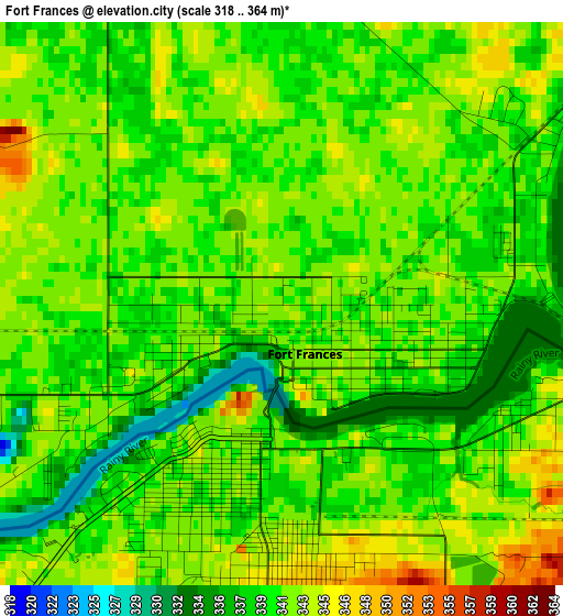
Below is the Elevation map of Fort Frances, which displays elevation range with different colors. Scale of the first map is from 318 to 364 m (1043 to 1194 ft) with average elevation of 340.7 meters (=1118 ft) [note 1]
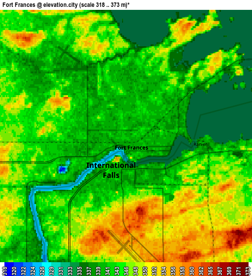
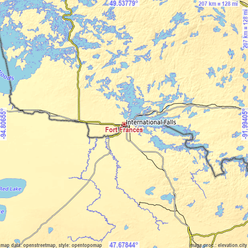
These maps also provides idea of topography and contour of this city, they are displayed at different zoom levels. More info about maps, scale and edge coordinates you can find below images.
| \ | Map #1 | Map #2 | Topo.Map |
| Scale [m] | 318..364 m | 318..373 m | × |
| Scale [ft] | 1043..1194 ft | 1043..1224 ft | × |
| Average | 340.7 m = 1118 ft | 343.8 m = 1128 ft | × |
| Width | 6.46 km = 4 mi | 12.92 km = 8 mi | 206.7 km = 128.4 mi |
| Height | 6.46 km = 4 mi | 12.92 km = 8 mi | 206.7 km = 128.4 mi |
| ↑Max Latitude | 48.645714° | 48.67474° | 49.53779° |
| Latitude at center | 48.61667° | 48.61667° | 48.61667° |
| ↓Min Latitude | 48.58761° | 48.558533° | 47.67844° |
| ← Min Longitude | -93.444245° | -93.488191° | -94.80655° |
| Longitude center | -93.4003° | -93.4003° | -93.4003° |
| →Max Longitude | -93.356355° | -93.312409° | -91.99405° |
Nearby cities:
Cities around Fort Frances sort by population:
• Kenora elevation 328 m
150.5 km,  328°
328°
• Steinbach 263 m
259.7 km,  292°
292°
• Dryden 387 m
138 km,  20°
20°
• Red Lake 374 m
268.6 km,  353°
353°
• Atikokan 390 m
131.3 km,  83°
83°
• Sioux Lookout 412 m
191.1 km,  32°
32°
• Grunthal 266 m
267.1 km, 289°
• Moose Lake 346 m
153.9 km,  295°
295°
• Golden 380 m
272.6 km, 354°
• Lac du Bonnet 261 m
264.8 km,  313°
313°
• La Broquerie 280 m
247 km, 293°
• Ear Falls 376 m
225.2 km,  3°
3°
Multilingual:
 En español:
Fort Frances elevación 340 m.
 En France:
Fort Frances élévation 340 m.
 Auf Deutsch:
Fort Frances höhe über dem Meeresspiegel ist 340 m.

Sources and notes:
- [note 1] Map square and city borders are not equal. Map elevation data is calculated only from area inside that square.
- [src 1] Elevation data from geonames database provided with same terms of usage.
- [src 2] The elevation map of Fort Frances is generated using elevation data from NASA's 3 arcsec (90m) resolution SRTM data.
- [src 3] Base (background) map © OpenStreetMap contributors tiles are generated by Geofabrik and OpenTopoMap.
Copyright & License:
This Fort Frances Elevation Map is licensed under CC BY-SA. You may reuse any part from this page, if you give a proper credit by linking to this URL:
 More info on terms of use page.