Steinbach elevation
Steinbach (Manitoba), Canada elevation is 263 meters and Steinbach elevation in feet is 863 ft above sea level [src 1]. Steinbach is a populated place (feature code) with elevation that is 5 meters (16 ft) bigger than average city elevation in Canada.
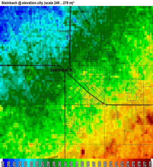
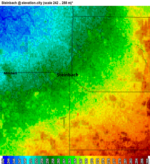
Below is the Elevation map of Steinbach, which displays elevation range with different colors. Scale of the first map is from 249 to 278 m (817 to 912 ft) with average elevation of 261.3 meters (=857 ft) [note 1]
These maps also provides idea of topography and contour of this city, they are displayed at different zoom levels. More info about maps, scale and edge coordinates you can find below images.
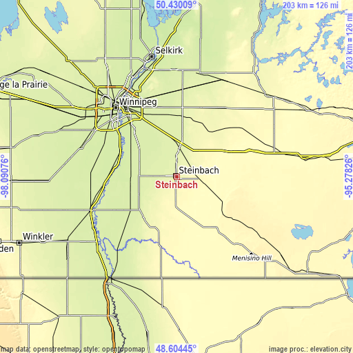
| \ | Map #1 | Map #2 | Topo.Map |
| Scale [m] | 249..278 m | 242..288 m | × |
| Scale [ft] | 817..912 ft | 794..945 ft | × |
| Average | 261.3 m = 857 ft | 263.2 m = 864 ft | × |
| Width | 6.34 km = 3.9 mi | 12.69 km = 7.9 mi | 203 km = 126.1 mi |
| Height | 6.34 km = 3.9 mi | 12.69 km = 7.9 mi | 203 km = 126.1 mi |
| ↑Max Latitude | 49.554307° | 49.582807° | 50.43009° |
| Latitude at center | 49.52579° | 49.52579° | 49.52579° |
| ↓Min Latitude | 49.497257° | 49.468706° | 48.60445° |
| ← Min Longitude | -96.728455° | -96.772401° | -98.09076° |
| Longitude center | -96.68451° | -96.68451° | -96.68451° |
| →Max Longitude | -96.640565° | -96.596619° | -95.27826° |
Nearby cities:
Cities around Steinbach sort by population:
• Winnipeg elevation 245 m
51.9 km,  320°
320°
• Selkirk 227 m
70.2 km,  348°
348°
• Headingley 239 m
65 km,  306°
306°
• Lorette 239 m
27.3 km,  330°
330°
• Beausejour 248 m
60.8 km,  11°
11°
• Niverville 235 m
27.3 km,  288°
288°
• Morris 236 m
52.8 km,  248°
248°
• Grunthal 266 m
18.3 km,  223°
223°
• Ile des Chênes 236 m
30.1 km, 313°
• St. Adolphe 234 m
34.9 km,  298°
298°
• Landmark 242 m
19 km, 328°
• La Broquerie 280 m
13.3 km,  94°
94°
Multilingual:
 En español:
Steinbach elevación 263 m.
 En France:
Steinbach élévation 263 m.
 Auf Deutsch:
Steinbach höhe über dem Meeresspiegel ist 263 m.

Sources and notes:
- [note 1] Map square and city borders are not equal. Map elevation data is calculated only from area inside that square.
- [src 1] Elevation data from geonames database provided with same terms of usage.
- [src 2] The elevation map of Steinbach is generated using elevation data from NASA's 3 arcsec (90m) resolution SRTM data.
- [src 3] Base (background) map © OpenStreetMap contributors tiles are generated by Geofabrik and OpenTopoMap.
Copyright & License:
This Steinbach Elevation Map is licensed under CC BY-SA. You may reuse any part from this page, if you give a proper credit by linking to this URL:
 More info on terms of use page.