Cornwall elevation
Cornwall (Ontario), Canada elevation is 59 meters and Cornwall elevation in feet is 194 ft above sea level [src 1]. Cornwall is a populated place (feature code) with elevation that is 199 meters (653 ft) smaller than average city elevation in Canada.
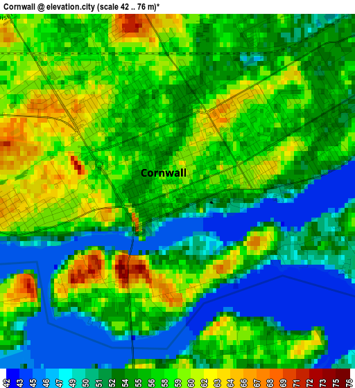
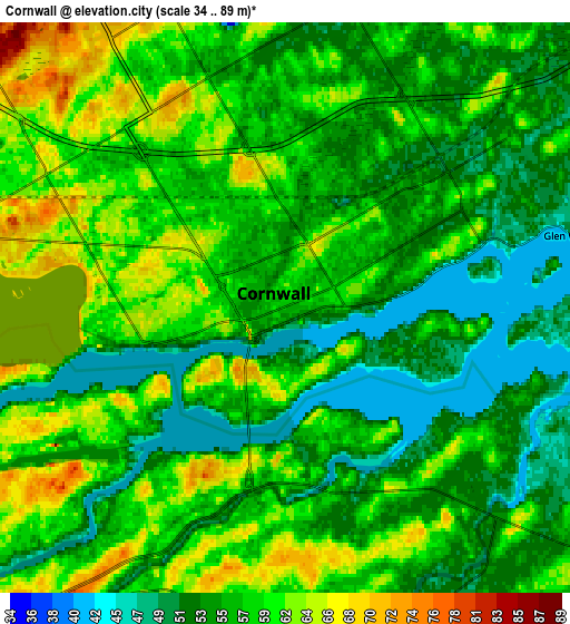
Below is the Elevation map of Cornwall, which displays elevation range with different colors. Scale of the first map is from 42 to 76 m (138 to 249 ft) with average elevation of 55.2 meters (=181 ft) [note 1]
These maps also provides idea of topography and contour of this city, they are displayed at different zoom levels. More info about maps, scale and edge coordinates you can find below images.
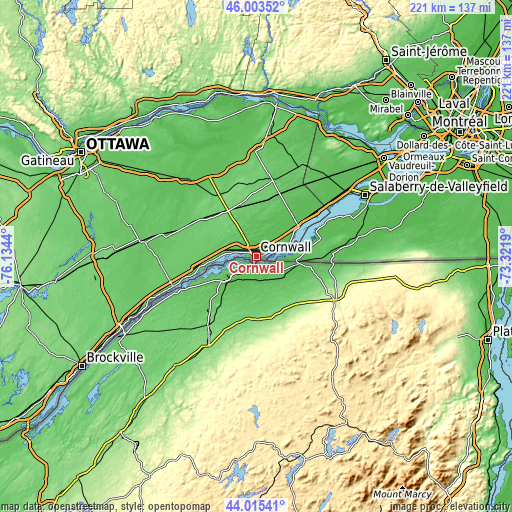
| \ | Map #1 | Map #2 | Topo.Map |
| Scale [m] | 42..76 m | 34..89 m | × |
| Scale [ft] | 138..249 ft | 112..292 ft | × |
| Average | 55.2 m = 181 ft | 57.1 m = 187 ft | × |
| Width | 6.91 km = 4.3 mi | 13.82 km = 8.6 mi | 221.1 km = 137.4 mi |
| Height | 6.91 km = 4.3 mi | 13.82 km = 8.6 mi | 221 km = 137.3 mi |
| ↑Max Latitude | 45.049146° | 45.080185° | 46.00352° |
| Latitude at center | 45.01809° | 45.01809° | 45.01809° |
| ↓Min Latitude | 44.987017° | 44.955928° | 44.01541° |
| ← Min Longitude | -74.772095° | -74.816041° | -76.1344° |
| Longitude center | -74.72815° | -74.72815° | -74.72815° |
| →Max Longitude | -74.684205° | -74.640259° | -73.3219° |
Nearby cities:
Cities around Cornwall sort by population:
• Salaberry-de-Valleyfield elevation 46 m
53.4 km,  61°
61°
• Les Coteaux 44 m
48.8 km,  52°
52°
• Coteau-du-Lac 46 m
53 km, 53°
• Saint-Zotique 47 m
45.6 km, 55°
• Russell 72 m
56.3 km,  297°
297°
• Casselman 64 m
43.3 km,  320°
320°
• Morrisburg 77 m
38.1 km,  249°
249°
• Huntingdon 48 m
44.8 km,  80°
80°
• Winchester 75 m
49.3 km,  278°
278°
• Limoges 68 m
53.8 km,  310°
310°
• Bourget 61 m
56.7 km, 324°
• Saint-Polycarpe 52 m
46 km, 47°
Multilingual:
 En español:
Cornwall elevación 59 m.
 En France:
Cornwall élévation 59 m.


Sources and notes:
- [note 1] Map square and city borders are not equal. Map elevation data is calculated only from area inside that square.
- [src 1] Elevation data from geonames database provided with same terms of usage.
- [src 2] The elevation map of Cornwall is generated using elevation data from NASA's 3 arcsec (90m) resolution SRTM data.
- [src 3] Base (background) map © OpenStreetMap contributors tiles are generated by Geofabrik and OpenTopoMap.
Copyright & License:
This Cornwall Elevation Map is licensed under CC BY-SA. You may reuse any part from this page, if you give a proper credit by linking to this URL:
 More info on terms of use page.