Bedford elevation
Bedford (Quebec, Montérégie), Canada elevation is 57 meters and Bedford elevation in feet is 187 ft above sea level [src 1]. Bedford is a populated place (feature code) with elevation that is 201 meters (659 ft) smaller than average city elevation in Canada.
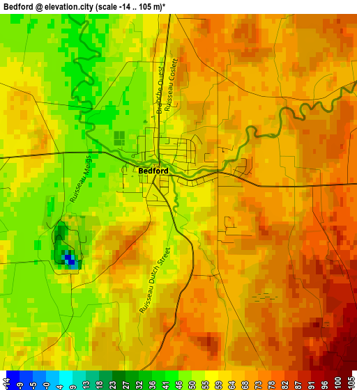
Below is the Elevation map of Bedford, which displays elevation range with different colors. Scale of the first map is from -14 to 105 m (-46 to 344 ft) with average elevation of 63.4 meters (=208 ft) [note 1]
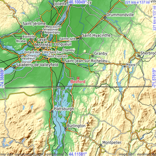
These maps also provides idea of topography and contour of this city, they are displayed at different zoom levels. More info about maps, scale and edge coordinates you can find below images.
| \ | Map #1 | Topo.Map |
| Scale [m] | -14..105 m | × |
| Scale [ft] | -46..344 ft | × |
| Average | 63.4 m = 208 ft | × |
| Width | 6.9 km = 4.3 mi | 220.7 km = 137.1 mi |
| Height | 6.9 km = 4.3 mi | 220.7 km = 137.1 mi |
| ↑Max Latitude | 45.147782° | 46.10049° |
| Latitude at center | 45.11678° | 45.11678° |
| ↓Min Latitude | 45.085761° | 44.11581° |
| ← Min Longitude | -73.026385° | -74.38869° |
| Longitude center | -72.98244° | -72.98244° |
| →Max Longitude | -72.938495° | -71.57619° |
Nearby cities:
Cities around Bedford sort by population:
• Saint-Jean-sur-Richelieu elevation 32 m
30.5 km,  313°
313°
• Cowansville 117 m
20.5 km,  63°
63°
• Farnham 55 m
18.5 km,  0°
0°
• Saint-Césaire 32 m
33.4 km,  357°
357°
• Sutton 176 m
28.8 km,  93°
93°
• Dunham 154 m
14.5 km,  82°
82°
• Mont-Saint-Grégoire 40 m
28 km,  329°
329°
• Ange-Gardien 71 m
26.2 km,  8°
8°
• Venise-en-Québec 29 m
12.3 km,  252°
252°
• Lacolle 40 m
30.3 km,  262°
262°
• Sainte-Croix 151 m
14.4 km, 82°
• Parc-Boutin 30 m
29.3 km, 311°
Multilingual:
 En español:
Bedford elevación 57 m.
 En France:
Bedford élévation 57 m.


Sources and notes:
- [note 1] Map square and city borders are not equal. Map elevation data is calculated only from area inside that square.
- [src 1] Elevation data from geonames database provided with same terms of usage.
- [src 2] The elevation map of Bedford is generated using elevation data from NASA's 3 arcsec (90m) resolution SRTM data.
- [src 3] Base (background) map © OpenStreetMap contributors tiles are generated by Geofabrik and OpenTopoMap.
Copyright & License:
This Bedford Elevation Map is licensed under CC BY-SA. You may reuse any part from this page, if you give a proper credit by linking to this URL:
 More info on terms of use page.