Mathambgwane elevation
Mathambgwane (Central), Botswana elevation is 1048 meters and Mathambgwane elevation in feet is 3438 ft above sea level [src 1]. Mathambgwane is a populated place (feature code) with elevation that is 36 meters (118 ft) bigger than average city elevation in Botswana.
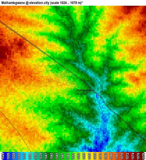
Below is the Elevation map of Mathambgwane, which displays elevation range with different colors. Scale of the first map is from 1024 to 1078 m (3360 to 3537 ft) with average elevation of 1051.7 meters (=3450 ft) [note 1]
These maps also provides idea of topography and contour of this city, they are displayed at different zoom levels. More info about maps, scale and edge coordinates you can find below images.
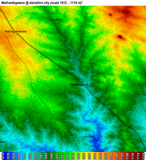
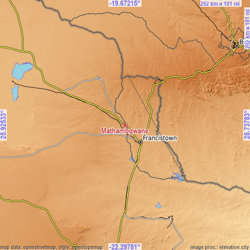
| \ | Map #1 | Map #2 | Topo.Map |
| Scale [m] | 1024..1078 m | 1012..1118 m | × |
| Scale [ft] | 3360..3537 ft | 3320..3668 ft | × |
| Average | 1051.7 m = 3450 ft | 1056.6 m = 3467 ft | × |
| Width | 9.12 km = 5.7 mi | 18.25 km = 11.3 mi | 291.9 km = 181.4 mi |
| Height | 9.12 km = 5.7 mi | 18.25 km = 11.3 mi | 292 km = 181.4 mi |
| ↑Max Latitude | -20.949715° | -20.908669° | -19.67215° |
| Latitude at center | -20.99075° | -20.99075° | -20.99075° |
| ↓Min Latitude | -21.031773° | -21.072785° | -22.29781° |
| ← Min Longitude | 27.287635° | 27.243689° | 25.92533° |
| Longitude center | 27.33158° | 27.33158° | 27.33158° |
| →Max Longitude | 27.375525° | 27.419471° | 28.73783° |
Nearby cities:
Cities around Mathambgwane sort by population:
• Francistown elevation 989 m
27 km,  137°
137°
• Selebi-Phikwe 870 m
122 km,  154°
154°
• Tonota 959 m
52 km,  164°
164°
• Nata 912 m
147.3 km,  305°
305°
• Sefophe 848 m
148 km, 153°
• Masunga 1199 m
42.5 km,  16°
16°
• Sebina 1071 m
16.2 km,  328°
328°
• Dukwe 961 m
105.3 km,  295°
295°
• Tobane 844 m
121.8 km, 151°
• Mosetse 1034 m
75.7 km,  290°
290°
• Mogapinyana 915 m
155.5 km,  169°
169°
• Makaleng 1064 m
11.3 km, 333°
Multilingual:
 En español:
Mathambgwane elevación 1048 m.
 En France:
Mathambgwane élévation 1048 m.
 Auf Deutsch:
Mathambgwane höhe über dem Meeresspiegel ist 1048 m.

Sources and notes:
- [note 1] Map square and city borders are not equal. Map elevation data is calculated only from area inside that square.
- [src 1] Elevation data from geonames database provided with same terms of usage.
- [src 2] The elevation map of Mathambgwane is generated using elevation data from NASA's 3 arcsec (90m) resolution SRTM data.
- [src 3] Base (background) map © OpenStreetMap contributors tiles are generated by Geofabrik and OpenTopoMap.
Copyright & License:
This Mathambgwane Elevation Map is licensed under CC BY-SA. You may reuse any part from this page, if you give a proper credit by linking to this URL:
 More info on terms of use page.