Nata elevation
Nata (Central), Botswana elevation is 912 meters and Nata elevation in feet is 2992 ft above sea level [src 1]. Nata is a populated place (feature code) with elevation that is 100 meters (328 ft) smaller than average city elevation in Botswana.
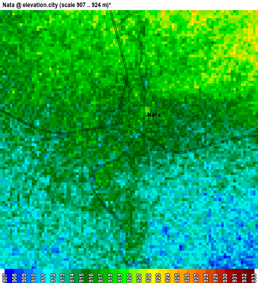
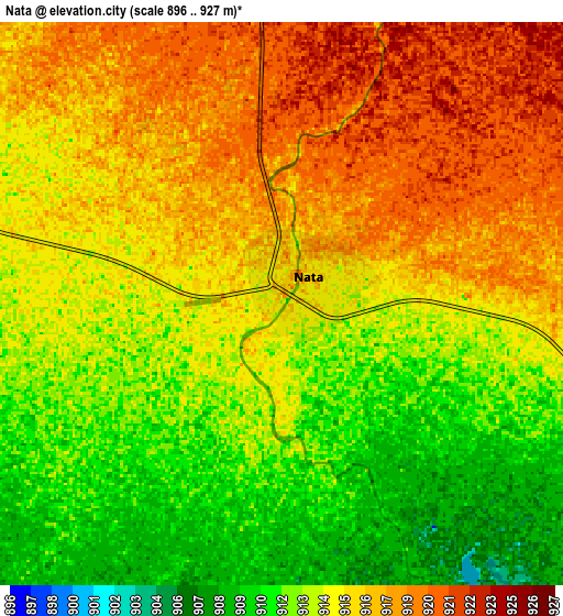
Below is the Elevation map of Nata, which displays elevation range with different colors. Scale of the first map is from 907 to 924 m (2976 to 3031 ft) with average elevation of 914.8 meters (=3001 ft) [note 1]
These maps also provides idea of topography and contour of this city, they are displayed at different zoom levels. More info about maps, scale and edge coordinates you can find below images.
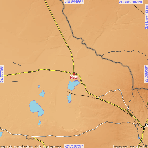
| \ | Map #1 | Map #2 | Topo.Map |
| Scale [m] | 907..924 m | 896..927 m | × |
| Scale [ft] | 2976..3031 ft | 2940..3041 ft | × |
| Average | 914.8 m = 3001 ft | 914.6 m = 3001 ft | × |
| Width | 9.17 km = 5.7 mi | 18.34 km = 11.4 mi | 293.4 km = 182.3 mi |
| Height | 9.17 km = 5.7 mi | 18.34 km = 11.4 mi | 293.5 km = 182.4 mi |
| ↑Max Latitude | -20.175427° | -20.134172° | -18.89156° |
| Latitude at center | -20.21667° | -20.21667° | -20.21667° |
| ↓Min Latitude | -20.257902° | -20.299124° | -21.53059° |
| ← Min Longitude | 26.139385° | 26.095439° | 24.77708° |
| Longitude center | 26.18333° | 26.18333° | 26.18333° |
| →Max Longitude | 26.227275° | 26.271221° | 27.58958° |
Nearby cities:
Cities around Nata sort by population:
• Francistown elevation 989 m
173.8 km,  127°
127°
• Letlhakane 984 m
146.7 km,  204°
204°
• Orapa 965 m
147.8 km,  214°
214°
• Gweta 929 m
99.2 km,  272°
272°
• Mathambgwane 1048 m
147.3 km, 125°
• Masunga 1199 m
139.4 km,  108°
108°
• Mopipi 906 m
172.7 km,  231°
231°
• Sua 929 m
18.6 km,  5°
5°
• Sebina 1071 m
132.5 km,  123°
123°
• Dukwe 961 m
47.5 km,  149°
149°
• Mosetse 1034 m
76.7 km,  140°
140°
• Makaleng 1064 m
137.4 km, 123°
Multilingual:
 En español:
Nata elevación 912 m.
 En France:
Nata élévation 912 m.


Sources and notes:
- [note 1] Map square and city borders are not equal. Map elevation data is calculated only from area inside that square.
- [src 1] Elevation data from geonames database provided with same terms of usage.
- [src 2] The elevation map of Nata is generated using elevation data from NASA's 3 arcsec (90m) resolution SRTM data.
- [src 3] Base (background) map © OpenStreetMap contributors tiles are generated by Geofabrik and OpenTopoMap.
Copyright & License:
This Nata Elevation Map is licensed under CC BY-SA. You may reuse any part from this page, if you give a proper credit by linking to this URL:
 More info on terms of use page.