Sefophe elevation
Sefophe (Central), Botswana elevation is 848 meters and Sefophe elevation in feet is 2782 ft above sea level [src 1]. Sefophe is a populated place (feature code) with elevation that is 164 meters (538 ft) smaller than average city elevation in Botswana.
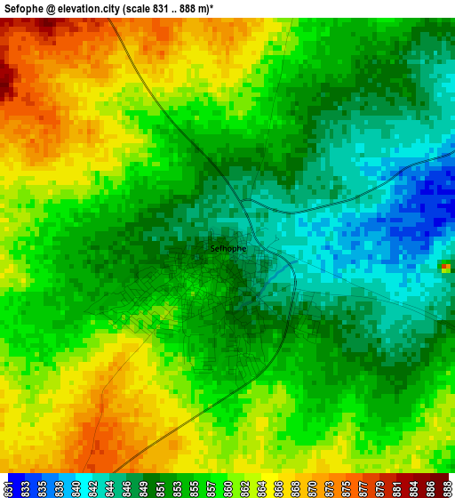
Below is the Elevation map of Sefophe, which displays elevation range with different colors. Scale of the first map is from 831 to 888 m (2726 to 2913 ft) with average elevation of 856.2 meters (=2809 ft) [note 1]
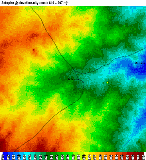
These maps also provides idea of topography and contour of this city, they are displayed at different zoom levels. More info about maps, scale and edge coordinates you can find below images.
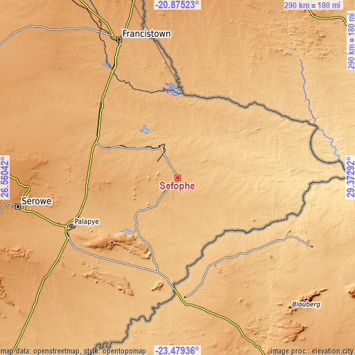
| \ | Map #1 | Map #2 | Topo.Map |
| Scale [m] | 831..888 m | 819..907 m | × |
| Scale [ft] | 2726..2913 ft | 2687..2976 ft | × |
| Average | 856.2 m = 2809 ft | 862.1 m = 2828 ft | × |
| Width | 9.05 km = 5.6 mi | 18.1 km = 11.2 mi | 289.6 km = 179.9 mi |
| Height | 9.05 km = 5.6 mi | 18.1 km = 11.2 mi | 289.6 km = 179.9 mi |
| ↑Max Latitude | -22.142632° | -22.101921° | -20.87523° |
| Latitude at center | -22.18333° | -22.18333° | -22.18333° |
| ↓Min Latitude | -22.224017° | -22.264691° | -23.47936° |
| ← Min Longitude | 27.922725° | 27.878779° | 26.56042° |
| Longitude center | 27.96667° | 27.96667° | 27.96667° |
| →Max Longitude | 28.010615° | 28.054561° | 29.37292° |
Nearby cities:
Cities around Sefophe sort by population:
• Selebi-Phikwe elevation 870 m
26.1 km,  330°
330°
• Maunatlala 856 m
57.6 km,  216°
216°
• Letsheng 977 m
93.2 km,  235°
235°
• Ratholo 924 m
72.6 km,  213°
213°
• Mathathane 676 m
81.1 km,  96°
96°
• Tobane 844 m
26.8 km,  345°
345°
• Mogapi 921 m
20.6 km, 221°
• Gobojango 737 m
87.7 km,  63°
63°
• Mogapinyana 915 m
42.9 km, 241°
• Maapi 938 m
90 km, 224°
• Mathakola 959 m
90.1 km,  228°
228°
• Tamasane 946 m
63.8 km,  245°
245°
Multilingual:
 En español:
Sefophe elevación 848 m.
 En France:
Sefophe élévation 848 m.


Sources and notes:
- [note 1] Map square and city borders are not equal. Map elevation data is calculated only from area inside that square.
- [src 1] Elevation data from geonames database provided with same terms of usage.
- [src 2] The elevation map of Sefophe is generated using elevation data from NASA's 3 arcsec (90m) resolution SRTM data.
- [src 3] Base (background) map © OpenStreetMap contributors tiles are generated by Geofabrik and OpenTopoMap.
Copyright & License:
This Sefophe Elevation Map is licensed under CC BY-SA. You may reuse any part from this page, if you give a proper credit by linking to this URL:
 More info on terms of use page.