Selebi-Phikwe elevation
Selebi-Phikwe (Selibe Phikwe), Botswana elevation is 870 meters and Selebi-Phikwe elevation in feet is 2854 ft above sea level [src 1]. Selebi-Phikwe is a populated place (feature code) with elevation that is 142 meters (466 ft) smaller than average city elevation in Botswana.
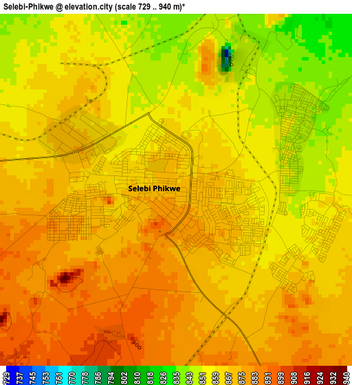
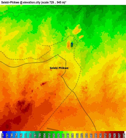
Below is the Elevation map of Selebi-Phikwe, which displays elevation range with different colors. Scale of the first map is from 729 to 940 m (2392 to 3084 ft) with average elevation of 865.1 meters (=2838 ft) [note 1]
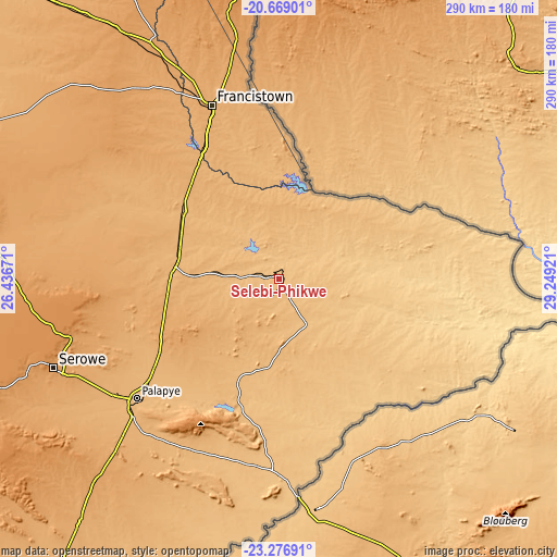
These maps also provides idea of topography and contour of this city, they are displayed at different zoom levels. More info about maps, scale and edge coordinates you can find below images.
| \ | Map #1 | Map #2 | Topo.Map |
| Scale [m] | 729..940 m | 729..945 m | × |
| Scale [ft] | 2392..3084 ft | 2392..3100 ft | × |
| Average | 865.1 m = 2838 ft | 864.8 m = 2837 ft | × |
| Width | 9.06 km = 5.6 mi | 18.12 km = 11.3 mi | 290 km = 180.2 mi |
| Height | 9.06 km = 5.6 mi | 18.12 km = 11.3 mi | 290 km = 180.2 mi |
| ↑Max Latitude | -21.938193° | -21.897424° | -20.66901° |
| Latitude at center | -21.97895° | -21.97895° | -21.97895° |
| ↓Min Latitude | -22.019696° | -22.060429° | -23.27691° |
| ← Min Longitude | 27.799015° | 27.755069° | 26.43671° |
| Longitude center | 27.84296° | 27.84296° | 27.84296° |
| →Max Longitude | 27.886905° | 27.930851° | 29.24921° |
Nearby cities:
Cities around Selebi-Phikwe sort by population:
• Francistown elevation 989 m
96.4 km,  338°
338°
• Palapye 926 m
97.1 km,  229°
229°
• Tonota 959 m
71.5 km,  326°
326°
• Sefophe 848 m
26.1 km,  150°
150°
• Maunatlala 856 m
72.1 km,  197°
197°
• Ratholo 924 m
87.5 km, 198°
• Mathathane 676 m
98.8 km,  109°
109°
• Tobane 844 m
6.7 km,  61°
61°
• Mogapi 921 m
38.3 km,  181°
181°
• Gobojango 737 m
92.8 km,  79°
79°
• Mogapinyana 915 m
49.8 km,  210°
210°
• Tamasane 946 m
66.7 km,  222°
222°
Multilingual:
 En español:
Selebi-Phikwe elevación 870 m.
 En France:
Selebi-Phikwe élévation 870 m.
 Auf Deutsch:
Selebi-Phikwe höhe über dem Meeresspiegel ist 870 m.

Sources and notes:
- [note 1] Map square and city borders are not equal. Map elevation data is calculated only from area inside that square.
- [src 1] Elevation data from geonames database provided with same terms of usage.
- [src 2] The elevation map of Selebi-Phikwe is generated using elevation data from NASA's 3 arcsec (90m) resolution SRTM data.
- [src 3] Base (background) map © OpenStreetMap contributors tiles are generated by Geofabrik and OpenTopoMap.
Copyright & License:
This Selebi-Phikwe Elevation Map is licensed under CC BY-SA. You may reuse any part from this page, if you give a proper credit by linking to this URL:
 More info on terms of use page.