Pemagatshel elevation
Pemagatshel, Bhutan elevation is 1207 meters and Pemagatshel elevation in feet is 3960 ft above sea level [src 1]. Pemagatshel is a seat of a first-order administrative division (feature code) with elevation that is 305 meters (1001 ft) smaller than average city elevation in Bhutan.
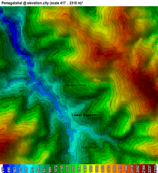
Below is the Elevation map of Pemagatshel, which displays elevation range with different colors. Scale of the first map is from 417 to 2310 m (1368 to 7579 ft) with average elevation of 1312.5 meters (=4306 ft) [note 1]
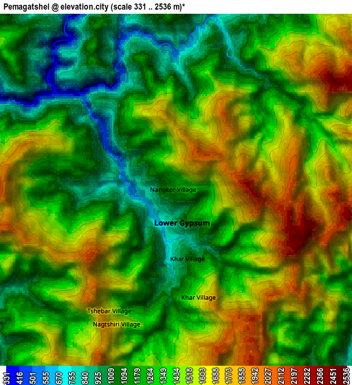
These maps also provides idea of topography and contour of this city, they are displayed at different zoom levels. More info about maps, scale and edge coordinates you can find below images.
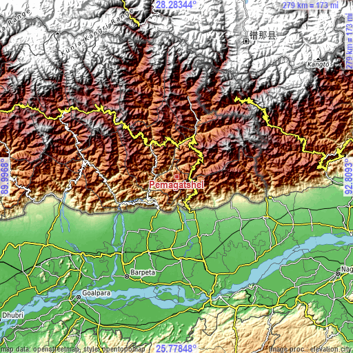
| \ | Map #1 | Map #2 | Topo.Map |
| Scale [m] | 417..2310 m | 331..2536 m | × |
| Scale [ft] | 1368..7579 ft | 1086..8320 ft | × |
| Average | 1312.5 m = 4306 ft | 1374 m = 4508 ft | × |
| Width | 8.7 km = 5.4 mi | 17.41 km = 10.8 mi | 278.5 km = 173.1 mi |
| Height | 8.7 km = 5.4 mi | 17.41 km = 10.8 mi | 278.5 km = 173.1 mi |
| ↑Max Latitude | 27.077086° | 27.116207° | 28.28344° |
| Latitude at center | 27.03795° | 27.03795° | 27.03795° |
| ↓Min Latitude | 26.998801° | 26.959638° | 25.77848° |
| ← Min Longitude | 91.359105° | 91.315159° | 89.9968° |
| Longitude center | 91.40305° | 91.40305° | 91.40305° |
| →Max Longitude | 91.446995° | 91.490941° | 92.8093° |
Nearby cities:
Cities around Pemagatshel sort by population:
• Tsirang elevation 1410 m
126.8 km,  269°
269°
• Sarpang 344 m
114.2 km,  260°
260°
• Samdrup Jongkhar 173 m
28.3 km,  159°
159°
• Jakar 2587 m
85.8 km,  311°
311°
• Trashi Yangtse 1788 m
64.5 km,  8°
8°
• Mongar 1648 m
30.9 km,  328°
328°
• Trongsa 2108 m
102.5 km,  300°
300°
• Daga 1558 m
151.2 km, 271°
• Panbang 214 m
45.8 km,  245°
245°
• Trashigang 1174 m
36.1 km,  24°
24°
• Shemgang 1900 m
76.4 km,  285°
285°
• Lhuentse 1403 m
73.3 km,  342°
342°
Multilingual:
 En español:
Pemagatshel elevación 1207 m.
 En France:
Pemagatshel élévation 1207 m.
 Auf Deutsch:
Pemagatshel höhe über dem Meeresspiegel ist 1207 m.

Sources and notes:
- [note 1] Map square and city borders are not equal. Map elevation data is calculated only from area inside that square.
- [src 1] Elevation data from geonames database provided with same terms of usage.
- [src 2] The elevation map of Pemagatshel is generated using elevation data from NASA's 3 arcsec (90m) resolution SRTM data.
- [src 3] Base (background) map © OpenStreetMap contributors tiles are generated by Geofabrik and OpenTopoMap.
Copyright & License:
This Pemagatshel Elevation Map is licensed under CC BY-SA. You may reuse any part from this page, if you give a proper credit by linking to this URL:
 More info on terms of use page.