Jakar elevation
Jakar (Bumthang), Bhutan elevation is 2587 meters and Jakar elevation in feet is 8488 ft above sea level [src 1]. Jakar is a seat of a first-order administrative division (feature code) with elevation that is 1075 meters (3527 ft) bigger than average city elevation in Bhutan.
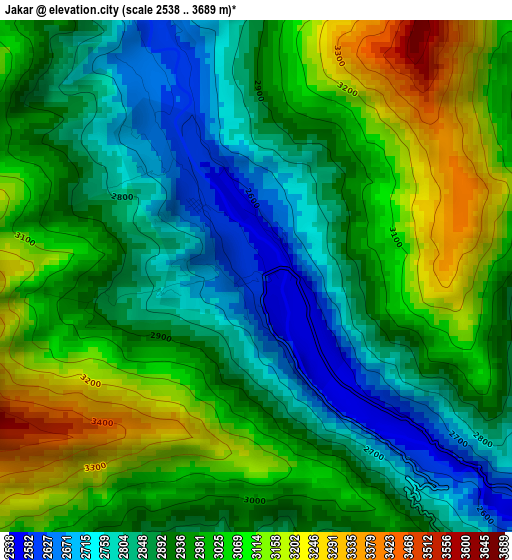
Below is the Elevation map of Jakar, which displays elevation range with different colors. Scale of the first map is from 2538 to 3689 m (8327 to 12103 ft) with average elevation of 2955.5 meters (=9697 ft) [note 1]
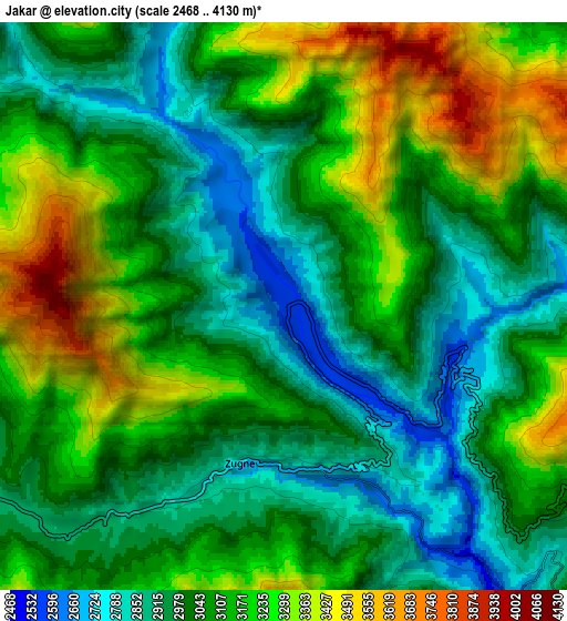
These maps also provides idea of topography and contour of this city, they are displayed at different zoom levels. More info about maps, scale and edge coordinates you can find below images.

| \ | Map #1 | Map #2 | Topo.Map |
| Scale [m] | 2538..3689 m | 2468..4130 m | × |
| Scale [ft] | 8327..12103 ft | 8097..13550 ft | × |
| Average | 2955.5 m = 9697 ft | 3089.5 m = 10136 ft | × |
| Width | 8.66 km = 5.4 mi | 17.33 km = 10.8 mi | 277.2 km = 172.2 mi |
| Height | 8.66 km = 5.4 mi | 17.33 km = 10.8 mi | 277.3 km = 172.3 mi |
| ↑Max Latitude | 27.588136° | 27.627077° | 28.78883° |
| Latitude at center | 27.54918° | 27.54918° | 27.54918° |
| ↓Min Latitude | 27.510211° | 27.471227° | 26.29538° |
| ← Min Longitude | 90.708555° | 90.664609° | 89.34625° |
| Longitude center | 90.7525° | 90.7525° | 90.7525° |
| →Max Longitude | 90.796445° | 90.840391° | 92.15875° |
Nearby cities:
Cities around Jakar sort by population:
• Punākha elevation 1293 m
86.4 km,  273°
273°
• Tsirang 1410 m
85.5 km,  226°
226°
• Pemagatshel 1207 m
85.8 km,  131°
131°
• Wangdue Phodrang 1273 m
84.4 km, 265°
• Pajo 1438 m
85.7 km, 268°
• Trashi Yangtse 1788 m
73.8 km,  84°
84°
• Mongar 1648 m
56.9 km,  122°
122°
• Trongsa 2108 m
24.7 km,  257°
257°
• Panbang 214 m
79.2 km,  163°
163°
• Trashigang 1174 m
82.7 km,  106°
106°
• Shemgang 1900 m
38.1 km,  194°
194°
• Lhuentse 1403 m
44.5 km,  72°
72°
Multilingual:
 En español:
Jakar elevación 2587 m.
 En France:
Jakar élévation 2587 m.


Sources and notes:
- [note 1] Map square and city borders are not equal. Map elevation data is calculated only from area inside that square.
- [src 1] Elevation data from geonames database provided with same terms of usage.
- [src 2] The elevation map of Jakar is generated using elevation data from NASA's 3 arcsec (90m) resolution SRTM data.
- [src 3] Base (background) map © OpenStreetMap contributors tiles are generated by Geofabrik and OpenTopoMap.
Copyright & License:
This Jakar Elevation Map is licensed under CC BY-SA. You may reuse any part from this page, if you give a proper credit by linking to this URL:
 More info on terms of use page.