Coari elevation
Coari (Amazonas), Brazil elevation is 42 meters and Coari elevation in feet is 138 ft above sea level [src 1]. Coari is a populated place (feature code) with elevation that is 340 meters (1115 ft) smaller than average city elevation in Brazil.
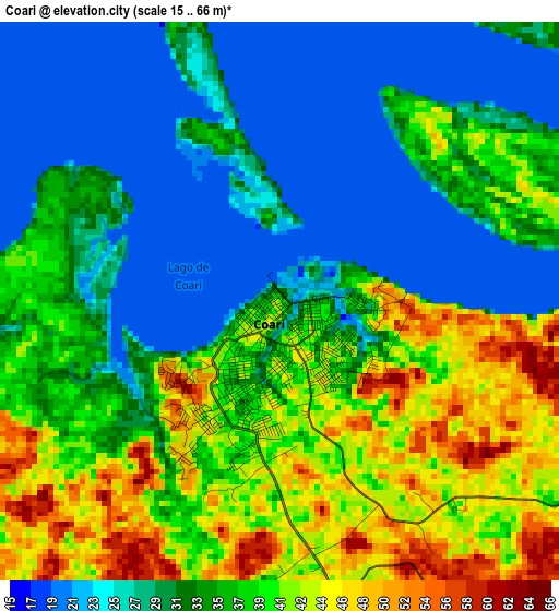
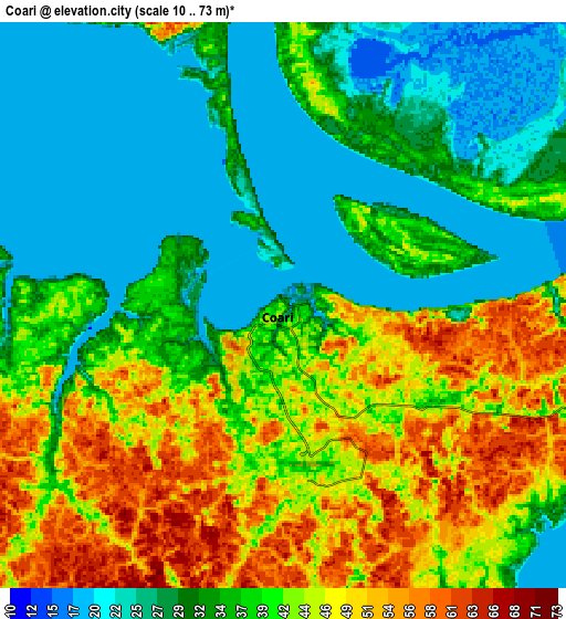
Below is the Elevation map of Coari, which displays elevation range with different colors. Scale of the first map is from 15 to 66 m (49 to 217 ft) with average elevation of 34.1 meters (=112 ft) [note 1]
These maps also provides idea of topography and contour of this city, they are displayed at different zoom levels. More info about maps, scale and edge coordinates you can find below images.
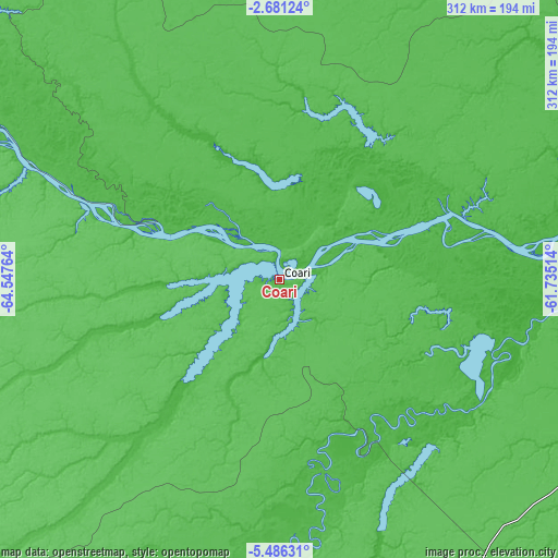
| \ | Map #1 | Map #2 | Topo.Map |
| Scale [m] | 15..66 m | 10..73 m | × |
| Scale [ft] | 49..217 ft | 33..240 ft | × |
| Average | 34.1 m = 112 ft | 36.9 m = 121 ft | × |
| Width | 9.75 km = 6.1 mi | 19.5 km = 12.1 mi | 311.9 km = 193.8 mi |
| Height | 9.75 km = 6.1 mi | 19.5 km = 12.1 mi | 311.9 km = 193.8 mi |
| ↑Max Latitude | -4.041165° | -3.997328° | -2.68124° |
| Latitude at center | -4.085° | -4.085° | -4.085° |
| ↓Min Latitude | -4.128832° | -4.172663° | -5.48631° |
| ← Min Longitude | -63.185335° | -63.229281° | -64.54764° |
| Longitude center | -63.14139° | -63.14139° | -63.14139° |
| →Max Longitude | -63.097445° | -63.053499° | -61.73514° |
Nearby cities:
Cities around Coari sort by population:
• Manacapuru elevation 34 m
293 km,  72°
72°
• Tefé 64 m
192.5 km,  294°
294°
• Manicoré 38 m
279.9 km,  133°
133°
• Codajás 30 m
123.4 km,  77°
77°
• Iranduba 29 m
339.8 km, 74°
• Novo Aripuanã 32 m
327 km,  110°
110°
• Manaquiri 27 m
321.3 km, 74°
• Anori 28 m
169.7 km, 78°
• Barcelos 35 m
346.8 km,  3°
3°
• Canutama 49 m
305 km,  206°
206°
• Alvarães 69 m
208 km,  297°
297°
• Uarini 56 m
249.9 km, 299°
Multilingual:
 En español:
Coari elevación 42 m.
 En France:
Coari élévation 42 m.


Sources and notes:
- [note 1] Map square and city borders are not equal. Map elevation data is calculated only from area inside that square.
- [src 1] Elevation data from geonames database provided with same terms of usage.
- [src 2] The elevation map of Coari is generated using elevation data from NASA's 3 arcsec (90m) resolution SRTM data.
- [src 3] Base (background) map © OpenStreetMap contributors tiles are generated by Geofabrik and OpenTopoMap.
Copyright & License:
This Coari Elevation Map is licensed under CC BY-SA. You may reuse any part from this page, if you give a proper credit by linking to this URL:
 More info on terms of use page.