Tefé elevation
Tefé (Amazonas), Brazil elevation is 64 meters and Tefé elevation in feet is 210 ft above sea level [src 1]. Tefé is a populated place (feature code) with elevation that is 318 meters (1043 ft) smaller than average city elevation in Brazil.
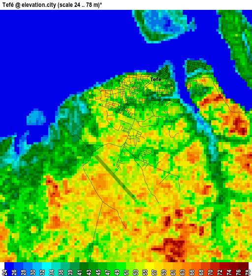
Below is the Elevation map of Tefé, which displays elevation range with different colors. Scale of the first map is from 24 to 78 m (79 to 256 ft) with average elevation of 43.8 meters (=144 ft) [note 1]
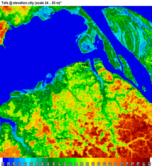
These maps also provides idea of topography and contour of this city, they are displayed at different zoom levels. More info about maps, scale and edge coordinates you can find below images.
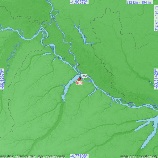
| \ | Map #1 | Map #2 | Topo.Map |
| Scale [m] | 24..78 m | 24..83 m | × |
| Scale [ft] | 79..256 ft | 79..272 ft | × |
| Average | 43.8 m = 144 ft | 44.8 m = 147 ft | × |
| Width | 9.76 km = 6.1 mi | 19.51 km = 12.1 mi | 312.1 km = 193.9 mi |
| Height | 9.76 km = 6.1 mi | 19.51 km = 12.1 mi | 312.2 km = 194 mi |
| ↑Max Latitude | -3.32454° | -3.280667° | -1.96372° |
| Latitude at center | -3.36841° | -3.36841° | -3.36841° |
| ↓Min Latitude | -3.412278° | -3.456145° | -4.77108° |
| ← Min Longitude | -64.764485° | -64.808431° | -66.12679° |
| Longitude center | -64.72054° | -64.72054° | -64.72054° |
| →Max Longitude | -64.676595° | -64.632649° | -63.31429° |
Nearby cities:
Cities around Tefé sort by population:
• Coari elevation 42 m
192.5 km,  114°
114°
• Carauari 65 m
294.2 km,  235°
235°
• Fonte Boa 60 m
179.5 km,  301°
301°
• Codajás 30 m
300.1 km,  99°
99°
• Anori 28 m
344.3 km, 97°
• Barcelos 35 m
332.6 km,  36°
36°
• Canutama 49 m
353.9 km,  173°
173°
• Alvarães 69 m
18.9 km,  330°
330°
• Tonantins 55 m
346.5 km,  279°
279°
• Maraã 74 m
185.8 km,  337°
337°
• Santa Isabel do Rio Negro 45 m
330.2 km,  354°
354°
• Uarini 56 m
60.2 km,  314°
314°
Multilingual:
 En español:
Tefé elevación 64 m.
 En France:
Tefé élévation 64 m.


Sources and notes:
- [note 1] Map square and city borders are not equal. Map elevation data is calculated only from area inside that square.
- [src 1] Elevation data from geonames database provided with same terms of usage.
- [src 2] The elevation map of Tefé is generated using elevation data from NASA's 3 arcsec (90m) resolution SRTM data.
- [src 3] Base (background) map © OpenStreetMap contributors tiles are generated by Geofabrik and OpenTopoMap.
Copyright & License:
This Tefé Elevation Map is licensed under CC BY-SA. You may reuse any part from this page, if you give a proper credit by linking to this URL:
 More info on terms of use page.