Iranduba elevation
Iranduba (Amazonas), Brazil elevation is 29 meters and Iranduba elevation in feet is 95 ft above sea level [src 1]. Iranduba is a populated place (feature code) with elevation that is 353 meters (1158 ft) smaller than average city elevation in Brazil.
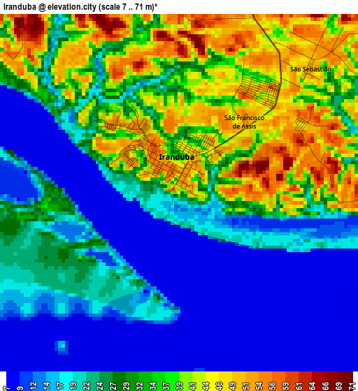
Below is the Elevation map of Iranduba, which displays elevation range with different colors. Scale of the first map is from 7 to 71 m (23 to 233 ft) with average elevation of 26.7 meters (=88 ft) [note 1]
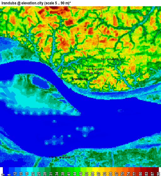
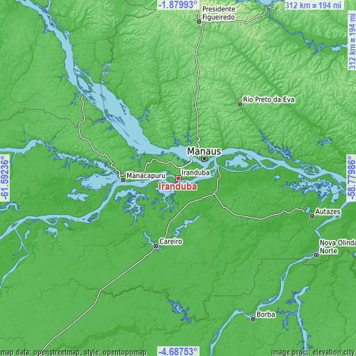
These maps also provides idea of topography and contour of this city, they are displayed at different zoom levels. More info about maps, scale and edge coordinates you can find below images.
| \ | Map #1 | Map #2 | Topo.Map |
| Scale [m] | 7..71 m | 5..90 m | × |
| Scale [ft] | 23..233 ft | 16..295 ft | × |
| Average | 26.7 m = 88 ft | 28.4 m = 93 ft | × |
| Width | 9.76 km = 6.1 mi | 19.51 km = 12.1 mi | 312.2 km = 194 mi |
| Height | 9.76 km = 6.1 mi | 19.51 km = 12.1 mi | 312.2 km = 194 mi |
| ↑Max Latitude | -3.240846° | -3.19697° | -1.87993° |
| Latitude at center | -3.28472° | -3.28472° | -3.28472° |
| ↓Min Latitude | -3.328592° | -3.372462° | -4.68753° |
| ← Min Longitude | -60.230055° | -60.274001° | -61.59236° |
| Longitude center | -60.18611° | -60.18611° | -60.18611° |
| →Max Longitude | -60.142165° | -60.098219° | -58.77986° |
Nearby cities:
Cities around Iranduba sort by population:
• Manaus elevation 20 m
27.1 km,  41°
41°
• Itacoatiara 19 m
194 km,  85°
85°
• Manacapuru 34 m
48.3 km,  268°
268°
• Rio Preto da Eva 39 m
84.6 km, 39°
• Nova Olinda do Norte 22 m
138.6 km,  119°
119°
• Borba 30 m
139.8 km,  151°
151°
• Codajás 30 m
216.5 km,  253°
253°
• Novo Aripuanã 32 m
205.3 km,  186°
186°
• Manaquiri 27 m
18.5 km,  258°
258°
• Autazes 23 m
121.7 km,  105°
105°
• Anori 28 m
170.7 km, 251°
• Careiro da Várzea 17 m
41.1 km,  76°
76°
Multilingual:
 En español:
Iranduba elevación 29 m.
 En France:
Iranduba élévation 29 m.


Sources and notes:
- [note 1] Map square and city borders are not equal. Map elevation data is calculated only from area inside that square.
- [src 1] Elevation data from geonames database provided with same terms of usage.
- [src 2] The elevation map of Iranduba is generated using elevation data from NASA's 3 arcsec (90m) resolution SRTM data.
- [src 3] Base (background) map © OpenStreetMap contributors tiles are generated by Geofabrik and OpenTopoMap.
Copyright & License:
This Iranduba Elevation Map is licensed under CC BY-SA. You may reuse any part from this page, if you give a proper credit by linking to this URL:
 More info on terms of use page.