Aimorés elevation
Aimorés (Minas Gerais), Brazil elevation is 79 meters and Aimorés elevation in feet is 259 ft above sea level [src 1]. Aimorés is a populated place (feature code) with elevation that is 303 meters (994 ft) smaller than average city elevation in Brazil.
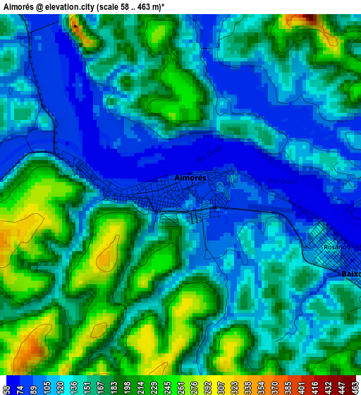
Below is the Elevation map of Aimorés, which displays elevation range with different colors. Scale of the first map is from 58 to 463 m (190 to 1519 ft) with average elevation of 154.5 meters (=507 ft) [note 1]
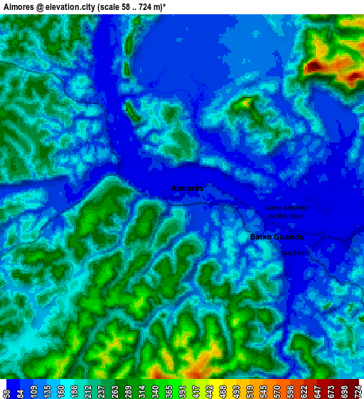
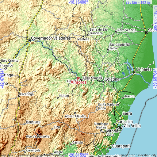
These maps also provides idea of topography and contour of this city, they are displayed at different zoom levels. More info about maps, scale and edge coordinates you can find below images.
| \ | Map #1 | Map #2 | Topo.Map |
| Scale [m] | 58..463 m | 58..724 m | × |
| Scale [ft] | 190..1519 ft | 190..2375 ft | × |
| Average | 154.5 m = 507 ft | 181 m = 594 ft | × |
| Width | 9.21 km = 5.7 mi | 18.42 km = 11.4 mi | 294.8 km = 183.2 mi |
| Height | 9.21 km = 5.7 mi | 18.42 km = 11.4 mi | 294.8 km = 183.2 mi |
| ↑Max Latitude | -19.454399° | -19.412957° | -18.16488° |
| Latitude at center | -19.49583° | -19.49583° | -19.49583° |
| ↓Min Latitude | -19.53725° | -19.57866° | -20.81592° |
| ← Min Longitude | -41.107835° | -41.151781° | -42.47014° |
| Longitude center | -41.06389° | -41.06389° | -41.06389° |
| →Max Longitude | -41.019945° | -40.975999° | -39.65764° |
Nearby cities:
Cities around Aimorés sort by population:
• Colatina elevation 82 m
45.7 km,  96°
96°
• Baixo Guandu 78 m
5.7 km,  116°
116°
• Resplendor 99 m
27.6 km,  313°
313°
• Afonso Cláudio 368 m
64.6 km,  185°
185°
• Conselheiro Pena 124 m
55.9 km, 310°
• Mutum 223 m
51.8 km,  229°
229°
• Itaguaçu 134 m
40.4 km,  147°
147°
• Pancas 119 m
37.5 km,  36°
36°
• Itarana 193 m
46.4 km, 154°
• Marilândia 88 m
55.5 km,  80°
80°
• Laranja da Terra 199 m
44.8 km,  179°
179°
• Águia Branca 143 m
66.4 km,  30°
30°
Multilingual:
 En español:
Aimorés elevación 79 m.
 En France:
Aimorés élévation 79 m.


Sources and notes:
- [note 1] Map square and city borders are not equal. Map elevation data is calculated only from area inside that square.
- [src 1] Elevation data from geonames database provided with same terms of usage.
- [src 2] The elevation map of Aimorés is generated using elevation data from NASA's 3 arcsec (90m) resolution SRTM data.
- [src 3] Base (background) map © OpenStreetMap contributors tiles are generated by Geofabrik and OpenTopoMap.
Copyright & License:
This Aimorés Elevation Map is licensed under CC BY-SA. You may reuse any part from this page, if you give a proper credit by linking to this URL:
 More info on terms of use page.