Afonso Cláudio elevation
Afonso Cláudio (Espírito Santo), Brazil elevation is 368 meters and Afonso Cláudio elevation in feet is 1207 ft above sea level [src 1]. Afonso Cláudio is a populated place (feature code) with elevation that is 14 meters (46 ft) smaller than average city elevation in Brazil.
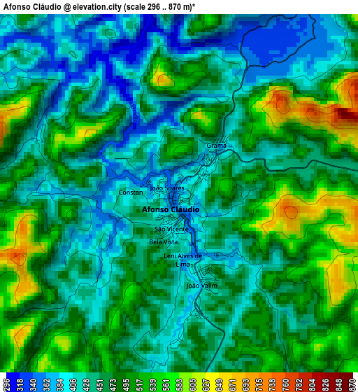
Below is the Elevation map of Afonso Cláudio, which displays elevation range with different colors. Scale of the first map is from 296 to 870 m (971 to 2854 ft) with average elevation of 464.5 meters (=1524 ft) [note 1]
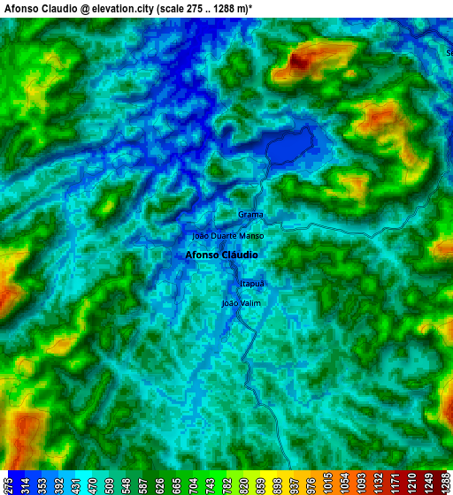
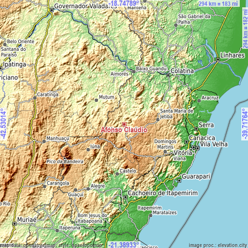
These maps also provides idea of topography and contour of this city, they are displayed at different zoom levels. More info about maps, scale and edge coordinates you can find below images.
| \ | Map #1 | Map #2 | Topo.Map |
| Scale [m] | 296..870 m | 275..1288 m | × |
| Scale [ft] | 971..2854 ft | 902..4226 ft | × |
| Average | 464.5 m = 1524 ft | 548.2 m = 1799 ft | × |
| Width | 9.18 km = 5.7 mi | 18.36 km = 11.4 mi | 293.7 km = 182.5 mi |
| Height | 9.18 km = 5.7 mi | 18.36 km = 11.4 mi | 293.7 km = 182.5 mi |
| ↑Max Latitude | -20.032889° | -19.991597° | -18.74789° |
| Latitude at center | -20.07417° | -20.07417° | -20.07417° |
| ↓Min Latitude | -20.11544° | -20.156699° | -21.38933° |
| ← Min Longitude | -41.167835° | -41.211781° | -42.53014° |
| Longitude center | -41.12389° | -41.12389° | -41.12389° |
| →Max Longitude | -41.079945° | -41.035999° | -39.71764° |
Nearby cities:
Cities around Afonso Cláudio sort by population:
• Lajinha elevation 491 m
52.8 km,  260°
260°
• Iúna 670 m
52.5 km,  234°
234°
• Santa Maria de Jetibá 819 m
40.1 km,  82°
82°
• Mutum 223 m
44.8 km,  312°
312°
• Ibatiba 750 m
44.1 km,  246°
246°
• Santa Teresa 656 m
56.8 km,  74°
74°
• Muniz Freire 555 m
52.8 km,  214°
214°
• Itaguaçu 134 m
41.3 km,  42°
42°
• Jetibá 678 m
46.6 km, 82°
• Conceição do Castelo 722 m
35 km,  200°
200°
• Itarana 193 m
34.2 km,  49°
49°
• Laranja da Terra 199 m
20.7 km,  19°
19°
Multilingual:
 En español:
Afonso Cláudio elevación 368 m.
 En France:
Afonso Cláudio élévation 368 m.
 Auf Deutsch:
Afonso Cláudio höhe über dem Meeresspiegel ist 368 m.

Sources and notes:
- [note 1] Map square and city borders are not equal. Map elevation data is calculated only from area inside that square.
- [src 1] Elevation data from geonames database provided with same terms of usage.
- [src 2] The elevation map of Afonso Cláudio is generated using elevation data from NASA's 3 arcsec (90m) resolution SRTM data.
- [src 3] Base (background) map © OpenStreetMap contributors tiles are generated by Geofabrik and OpenTopoMap.
Copyright & License:
This Afonso Cláudio Elevation Map is licensed under CC BY-SA. You may reuse any part from this page, if you give a proper credit by linking to this URL:
 More info on terms of use page.