Pancas elevation
Pancas (Espírito Santo), Brazil elevation is 119 meters and Pancas elevation in feet is 390 ft above sea level [src 1]. Pancas is a populated place (feature code) with elevation that is 263 meters (863 ft) smaller than average city elevation in Brazil.
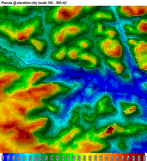
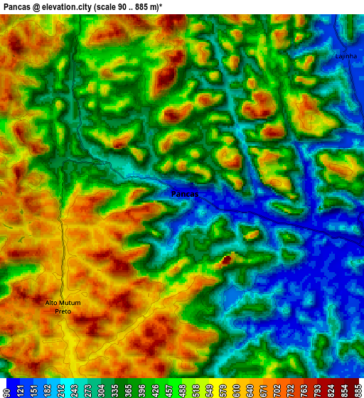
Below is the Elevation map of Pancas, which displays elevation range with different colors. Scale of the first map is from 100 to 885 m (328 to 2904 ft) with average elevation of 405.8 meters (=1331 ft) [note 1]
These maps also provides idea of topography and contour of this city, they are displayed at different zoom levels. More info about maps, scale and edge coordinates you can find below images.
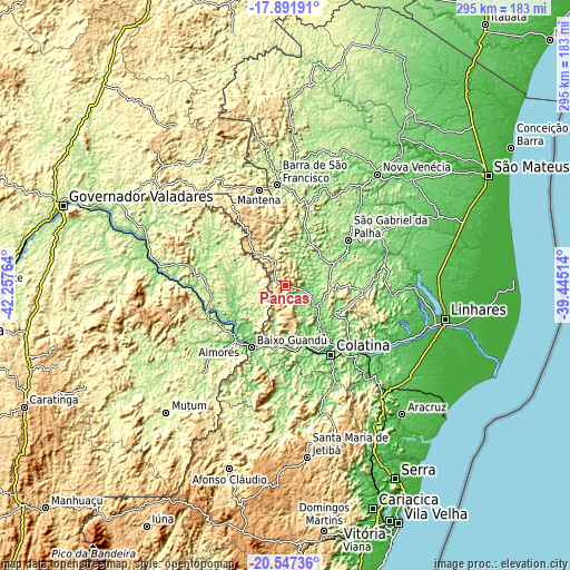
| \ | Map #1 | Map #2 | Topo.Map |
| Scale [m] | 100..885 m | 90..885 m | × |
| Scale [ft] | 328..2904 ft | 295..2904 ft | × |
| Average | 405.8 m = 1331 ft | 438.2 m = 1438 ft | × |
| Width | 9.23 km = 5.7 mi | 18.46 km = 11.5 mi | 295.3 km = 183.5 mi |
| Height | 9.23 km = 5.7 mi | 18.46 km = 11.5 mi | 295.3 km = 183.5 mi |
| ↑Max Latitude | -19.1835° | -19.14199° | -17.89191° |
| Latitude at center | -19.225° | -19.225° | -19.225° |
| ↓Min Latitude | -19.266489° | -19.307968° | -20.54736° |
| ← Min Longitude | -40.895335° | -40.939281° | -42.25764° |
| Longitude center | -40.85139° | -40.85139° | -40.85139° |
| →Max Longitude | -40.807445° | -40.763499° | -39.44514° |
Nearby cities:
Cities around Pancas sort by population:
• Colatina elevation 82 m
41.9 km,  146°
146°
• Barra de São Francisco 197 m
52.4 km,  355°
355°
• Baixo Guandu 78 m
37 km,  207°
207°
• Aimorés 79 m
37.5 km,  216°
216°
• Resplendor 99 m
43.8 km,  255°
255°
• Conselheiro Pena 124 m
65.5 km,  275°
275°
• Mantenópolis 413 m
49.4 km,  324°
324°
• Itaguaçu 134 m
64.2 km,  180°
180°
• Rio Bananal 70 m
54.6 km,  94°
94°
• Itarana 193 m
72.2 km, 181°
• Marilândia 88 m
38.6 km,  122°
122°
• Águia Branca 143 m
29.3 km,  23°
23°
Multilingual:
 En español:
Pancas elevación 119 m.
 En France:
Pancas élévation 119 m.


Sources and notes:
- [note 1] Map square and city borders are not equal. Map elevation data is calculated only from area inside that square.
- [src 1] Elevation data from geonames database provided with same terms of usage.
- [src 2] The elevation map of Pancas is generated using elevation data from NASA's 3 arcsec (90m) resolution SRTM data.
- [src 3] Base (background) map © OpenStreetMap contributors tiles are generated by Geofabrik and OpenTopoMap.
Copyright & License:
This Pancas Elevation Map is licensed under CC BY-SA. You may reuse any part from this page, if you give a proper credit by linking to this URL:
 More info on terms of use page.